The Posted Past marks its one year anniversary with fun, facts, and cats!
A year ago, The Posted Past began with a simple quest—to explore the stories behind my family’s vintage postcard collection. These small windows into the past gave me the chance to be curious and brave as a writer. I wasn’t sure I could research and produce a short essay on a weekly schedule. Fifty-two weeks later, without a single miss, I am happily beyond those worries.
Thank you for joining me on this journey. Together, we’ve traveled from Osaka to Matoon. Looked at buffalos roaming in a Kansas field and donkeys on the English seaside. Iconic views of San Francisco came from its well-known chronicler, and we’ve been on a more recent search for a Mexican photographer who vanished in volcanic ash. Each postcard has taken us to unexpected corners of history—social movements, architectural trends, national parks, and the everyday lives of people who took the time to write, “Wish you were here.”
Today’s postcard reminds me why I love this work. The adorable kittens and lovely roses on the front never go out of style. On the flipside, Maude writes to her mum with a few sweet sentiments and concerns. In between lies a world of personal and cultural histories: the rise of the postcard era, the Victorian language of flowers, the printing techniques that made such colorful cards possible, and the universality of cats. Always, an exchange between people. What we’re really collecting are reminders of tender human connections across time.
What’s new for year two? July will bring a shift in weekly format while I take some vacation time—shorter Wednesday posts spotlighting single cards. After that, I’ll be expanding the eBay store, indulging in the nerdy work of adding captions and citations to old posts, and exploring how these weekly essays might become a book and a workshop series. Like any creative start-up, the first year came with a to-do list of dreams and ideas.
Before I sign off, may I ask: would you ever consider sending a vintage postcard as a gift? The mechanics are easy—choose the perfect card online, add a personal note, and we send it off with love through the post office. But is that something you’d enjoy giving or receiving? Leave me a note in the comments.
Thanks again, and meow for now 🙂 Enjoy the summer!
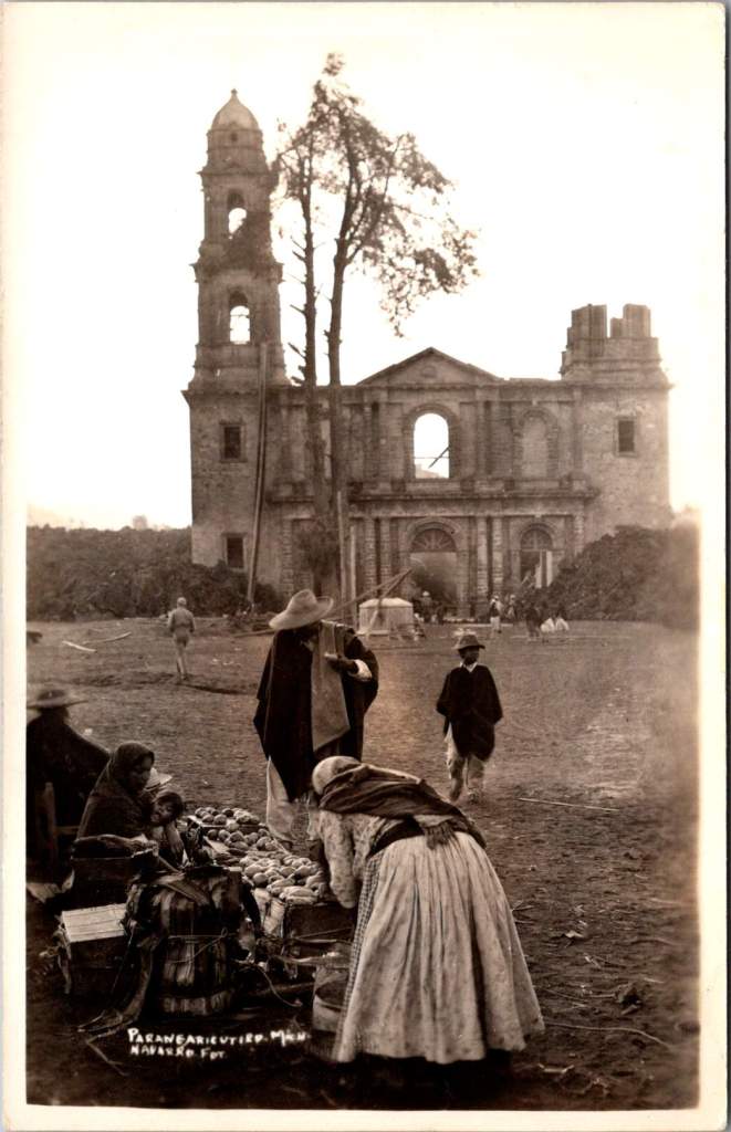
In February 1943, a photographer enigmatically known only as ‘Navarro’ documented Parícutin’s volcanic destruction of a Michoacán village and church, creating powerful postcards that circulated worldwide at the time and are highly collectible now. Then, Navarro vanished from history.
Parícutin erupted from Dionisio Pulido’s cornfield on February 20, 1943, becoming the first comprehensively documented volcanic birth in human history.
The response was immediate and international. Despite World War II, the Parícutin volcanic plumes commanded global coverage. The geological disruptions of fire and lava inspired scientific awe. Life Magazine dispatched photographers. Newsreels carried footage worldwide. Airlines altered flight paths for passenger viewing. By 1947, Hollywood used the still-active volcano as backdrop for the movie Captain from Castile, employing thousands of locals as extras.
In the extensive archives documenting Parícutin volcano’s nine-year life cycle, one name appears and vanishes: Navarro. His postcard images capture the most significant moment in the volcano’s terrifying story—when lava reached the 400-year-old church of San Juan Parangaricutiro. Despite meticulous record-keeping around this geological event, Navarro himself remains a mystery.
His photographs have more than survived. When story of the events at Parícutin are retold, one always finds a Navarro image. The photographer does appear in one other place: Folder 7 in Box 9 of the William F. Foshag archives.
The Day Lava Reached the Church
Navarro’s postcards document a sequence unfolding over a few crucial days in early 1943. For the year prior, the Purépecha community of San Juan Parangaricutiro had watched lava flows advance on their small village while praying their homes, farms, and colonial church would be spared.
Despite their pleas and processions, the lava flow had accelerated beyond divine intervention. President Lázaro Cárdenas and local priests convinced most residents to evacuate, carrying sacred objects and any moveable materials to the nearby town of Uruapan. One rare slice of film shows men removing clay tiles from a building roof.
When the lava reached the church, Navarro was there to document the destruction. Black lava creeping around the church’s perimeter. Intense heat causing wooden elements to combust. Steady accumulation of cooled volcanic rock against the baroque stone façade, contrasting human craftsmanship with geological force.
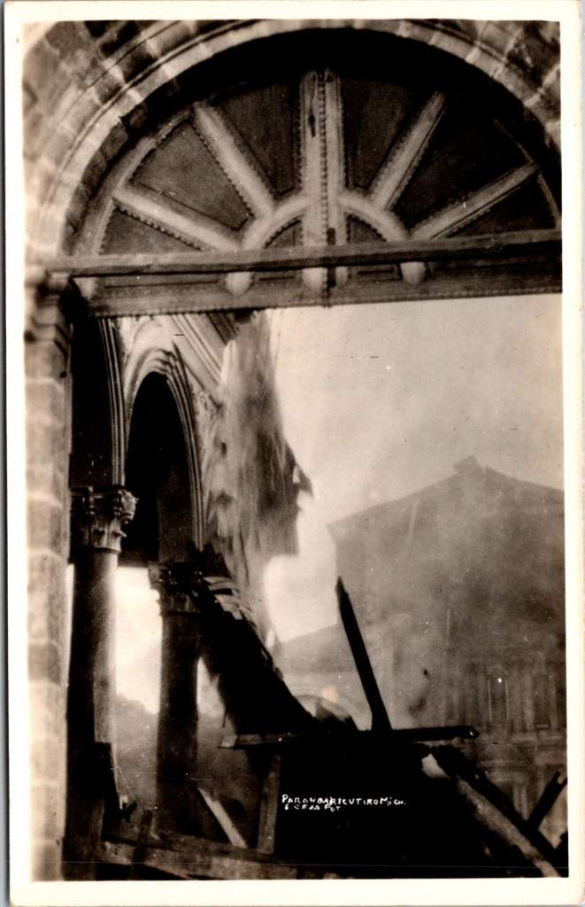
Two striking images captures the church’s wooden elements on fire—ornate arched stonework and columns holding the structure up while everything else is consumed. Extending the mystery further, these two images bear exactly the same mark and style of the others, but a different name is entirely obscured. Perhaps it makes sense, Navarro and another photographer would go together. Better than alone.
Foshag and the Official Record
William Frederick Foshag of the Smithsonian Institution’s National Museum led Parícutin’s scientific research and systematic documentation. A respected mineralogist and curator, Foshag had already spent his career studying volcanic minerals and processes. When Parícutin erupted, he was uniquely positioned to lead the most comprehensive study of a volcano’s complete life cycle.
Foshag arrived within weeks of the initial eruption and remained involved until the volcano’s dormancy in 1952. Working with Mexican geologist Dr. Jenaro González Reyna, he established a research station documenting every phase of development. Their collaboration produced detailed maps, temperature measurements, chemical analyses, and thousands of photographs fundamental to volcanic research today.
Navarro’s church sequence suggests either remarkable intuition, access to local knowledge, or information coming from scientific observers. The Purépecha community, drawing on generations of volcanic experience, provided crucial insights about timing and the landscape. Navarro’s ability to be there for the church’s final moments indicates he was plugged in.
Foshag’s archives reveal an extensive network of colleagues contributing to this documentation. Box 9, Folder 7 bears Navarro’s name alongside numerous other photographers, artists, and local and international contacts. It seems Foshag recognized the value of different perspectives in creating a complete record.
The official scientific documentation benefited from all the independent photography produced at the time. Their paths very likely crossed with many others at work during critical days when the lava and ash threatened San Juan Parangaricutiro.
Kodak in Mexico
The real photo postcard industry supporting photographers like Navarro was sophisticated. Entrepreneurs traveled with complete darkroom setups in automobiles, developing film and producing finished postcards within hours. They sold to tourists, sent copies to newspapers, and maintained distribution networks across Mexico and the United States.
By 1943, Kodak had established a robust business providing both cameras and materials throughout Mexico. Navarro’s postcards bear the EKC (Eastman Kodak Company) indicia and are marked Kodak Mexicana, LTD. Navarro had access to standardized, high-quality photographic paper specifically designed for postcard production. This infrastructure allowed photographers to work with consistent materials as they traveled to remote locations.
This commercial system created a parallel archive to official scientific record, prioritizing dramatic visual impact and human interest. While Foshag documented systematic geological processes, Navarro captured moments resonating with public imagination: the church under siege, displaced communities, civilization meeting unstoppable natural forces.
The quality and consistency in images suggests professional training and equipment. His compositions demonstrate understanding of the landscape and evoke pathos. Combined with his access to Kodak’s professional-grade materials, we may assume Navarro was more than a concerned observer.
History’s Mysteries
Navarro’s fade from historical records reflects broader patterns in how scientific events get remembered. Official histories preserve institutional participants while quietly forgetting the names and stories of independent contributors. This is notable with Parícutin, where local Purépecha knowledge proved crucial to understanding volcanic behavior, yet indigenous voices were largely excluded from formal documentation.
Still, Navarro gives us another chance to go there ourselves for a glimpse of those extraordinary hours. His postcards circulated broadly through the popular means of the era—family correspondence, tourist collections, commercial distributors—and are highly collectible today.
As researchers study Foshag’s extensive archives, Navarro’s name remains a tantalizing fragment—present enough to suggest significance, absent enough to resist interpretation. His postcards survive in collections across North America, carrying their maker’s vision but not his story.
This persistence of mystery tells us something about how we remember extraordinary events. While institutions preserve official records with careful attribution, the broader network of individual contributors often dissolves into anonymity. Navarro represents countless others who showed up when history was being made, pointed cameras at crucial moments, contributed to our understanding of the world, and then vanished back into the crowd.
The photographs of the church’s destruction remain powerful because they capture something beyond ecological process—the moment when human scale met geological time and a community’s sacred center became a monument to forces beyond human control. Navarro was there to see it, and that’s a chance for us to remember the event and to admire him.
This essay was inspired by Elena, Maria, and Sandy – with gratitude.
Native Hawaiian wisdom, mainland capitalism, an LDS mission, and the birth of Pacific tourism. At the center, a banyan tree that has watched Hawaii transform for 120 years. This 1921 real photo postcard reveals the complexities of cultural exchange, migration, and travel over time.
In the photograph we are looking at today, the Moana Hotel rises like a palace from Waikiki Beach, its elegant wings stretching toward Diamond Head. A wooden pier extends into the Pacific. The building’s Victorian details hint at mainland American grandeur transplanted to the tropics. The “First Lady of Waikiki” opened as the territory’s first luxury resort, transforming a landscape once dotted with taro ponds and royal summer homes into the birthplace of Pacific tourism.
Built by wealthy landowner Walter Chamberlain Peacock and designed by architect Oliver G. Traphagen, the Moana opened on March 11, 1901, with 75 rooms featuring Hawaii’s first electric elevator and the unique amenity of private bathrooms. The first guests were a group of Shriners, who paid $1.50 per night—about $50 today—to experience what was then a very remote luxury destination.
Three years later, Jared Smith, Director of the Department of Agriculture Experiment Station, planted what seemed like a simple landscaping choice in the hotel’s courtyard: a young Indian banyan tree, nearly seven feet tall and about seven years old when planted. In the image, the tree is seventeen years old and already creating the shaded sanctuary that is the hotel’s heart even today.
As we flip the postcard over, another dimension is revealed. On November 29, 1921, a simple message sent to Mabel Moss in Longanoxie, Kansas with the usual greetings. But this isn’t a holiday for Aunt Olive. Her return address, “Route 4 – Box 46,” tells its own story of how communities were connecting between ancient and modern, sacred and commercial.
A Mormon Pioneer’s Island Home
Aunt Olive likely lived in Laie, thirty-five miles north of the Moana Hotel, where the Mormon Church had established its Pacific sanctuary. Her Route 4 address would have been served by one of the Rural Free Delivery routes radiating out from Honolulu—a detail that places her among the settlers who were building new communities beyond the city’s tourist corridor.
The Mormon settlement at Laie represented a unique form of cultural encounter. Beginning in 1865, when Church president Brigham Young received permission from King Kamehameha V to establish an agricultural colony, the Latter-Day Saints purchased 6,000 acres of traditional land—a pie-shaped division that provided for sustainable living. The Mormon community tried to honor Hawaiian land practices, giving each family a loi (water garden) to cultivate kalo (taro), the traditional sustenance crop.
The Hawaii Temple, dedicated in 1919, was the first Mormon temple outside continental North America. Built with crushed local lava and coral, its structure embodied the meeting of mainland pioneer culture and Pacific Island materials. Polynesian Saints from across the Pacific were gathering in Laie to receive temple ordinances, creating a multicultural religious community where Hawaiian, Samoan, Maori, and haole (white) families lived side by side.
The LDS approach to missionary work emphasizes learning local languages and customs—not merely as conversion strategy, but as theological principle. One of the early missionaries mastered Hawaiian so thoroughly that he produced the first non-English translation of the Book of Mormon in 1855. The missionaries married into Hawaiian families, adopted local foods and farming methods, and incorporated Polynesian cultural elements into their worship. Even as they openly sought converts, they also saw themselves as students of Hawaiian wisdom.
Paradise Shared
Captured in our image are at least a few conflicting visions of paradise. The Moana Hotel itself represents economic prosperity through the commodification of tropical beauty. Its guests paid premium rates to experience “the ultimate playground,” complete with hula shows and exotic imagery designed for mainland consumption. By the time of this photo, the hotel’s success had already inspired expansion; wings added in 1918 doubled its capacity.
However, the hotel was built where Hawaiian royalty had once gathered, in a place that embodied the Native Hawaiian principles, very different than Western concepts of land as commodity, beauty as product, and culture as entertainment. Look again at the Banyan tree. Where tourists saw scenery, Native Hawaiians understood kino lau—the gods manifested in every plant, animal, and natural feature. But, Hawaiian language had been banned in schools since 1896, and traditional practices were actively discouraged as territorial authorities promoted “Americanization.”
The Mormon community at Laie offered a third way that, despite its evangelical aims, required genuine cultural engagement. Unlike tourists who consumed Hawaiian imagery, or territorial officials who suppressed Hawaiian practices, Mormon missionaries made learning local ways a theological priority. They understood that successful evangelism required fluency not just in Hawaiian language, but in Hawaiian concepts of kinship, land, and spirituality.
This approach created communities that were simultaneously foreign settlements and island adaptations—places where pioneer traditions mixed with Polynesian extended family structures, where American church hymns were sung in native dialects, and where temple architecture incorporated local materials and building techniques.
Time Travel
The tensions that were at work in 1921 continue today, but so do the possibilities for meaningful cultural exchange. Today’s mālama Hawaii movement invites travelers to participate in coral restoration, native forest planting, and beach cleanups. Visitors can learn about places like Waimea Valley, where ancient cultural sites are preserved alongside environmental restoration. The principle of pono—righteous action—guides travelers to maintain respectful distances from endangered monk seals and sea turtles, to support Native Hawaiian-owned businesses, and to understand that they are guests in a living culture, not a theme park.
The island time we seek now isn’t the vacation fantasy of escape from responsibility, but the deeper rhythm of understanding our place within larger cycles of care and connection. When we travel with curiosity rather than conquest, we discover that the most valuable treasures are the stories and perspectives we gather. Over time, we come to know that every place on Earth is someone’s sacred ground.
In Hawaiian tradition, banyan trees serve as gathering places for spirits, bridges between the physical and spiritual worlds. Perhaps this ancient wisdom explains why the Moana Hotel’s banyan courtyard remains a place of peace amid Waikiki’s transformation—a living reminder that some forms of growth honor rather than diminish what came before.
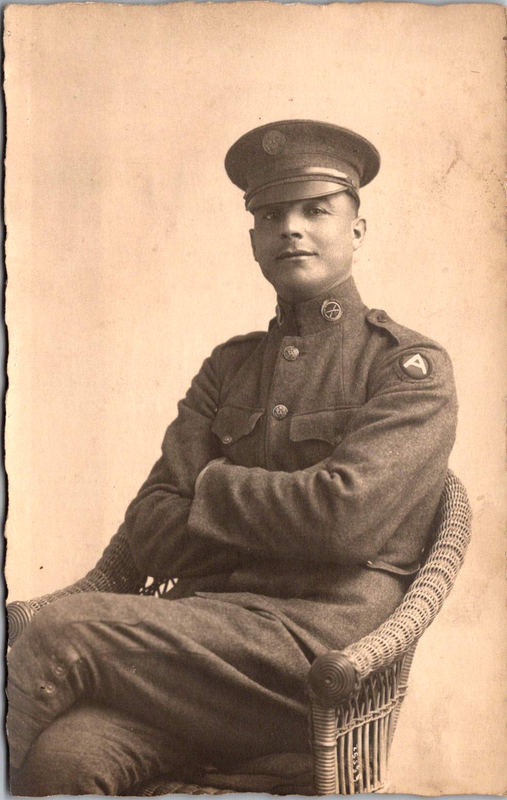
A lone Buffalo Soldier on horseback captures a moment of dignity in African American military history.
Real Photo Postcards (RPPCs) offer tangible connections to history, yet they often emerge from a family photo album or shoebox collection entirely without context. Piecing together their stories requires careful observation and historical research, picking up valuable clues along the way.
Today’s case is an image of a lone Buffalo Soldier on horseback, printed sometime between 1904 and 1918. This postcard captures a moment of dignity in African American military history. The soldier sits tall in the saddle, wearing a formal military dress cap (rather than the campaign hat often associated with frontier service) and a meticulously maintained uniform. The setting—featuring a substantial brick building and cement sidewalk—suggests an established military installation rather than a frontier outpost.
The man is likely from the 9th or 10th Cavalry, and two military posts stand out: Fort Robinson in Nebraska and Fort Myer in Virginia, both important locations in Buffalo Soldier history.
Western Bastion
From 1887 to 1898, Fort Robinson served as Regimental Headquarters for Buffalo Soldier cavalry and infantry units. The 9th Cavalry Regiment made its headquarters there beginning in 1887, serving with distinction and boasting ten Medal of Honor winners from the Indian Wars. The Buffalo Soldiers at Fort Robinson earned a reputation for discipline and effectiveness that would later influence their assignments to more prestigious postings.
The 10th Cavalry Regiment maintained a significant presence at Fort Robinson during the early 1900s. The substantial brick buildings and newly constructed cement sidewalks visible in the photograph align with Fort Robinson’s infrastructure during this period, as the fort underwent significant modernization around this time. The formal dress uniform and cap in the photograph suggest this might have been a commissioned officer or a non-commissioned officer in a ceremonial or garrison role at the fort.
Nation’s Capital
Troop K of the 9th Cavalry served at Fort Myer in Virginia from May 25, 1891, to October 3, 1894, under the command of Major Guy Henry, a Medal of Honor recipient. This prestigious assignment bears a direct link to Fort Robinson. The selection of Troop K for this assignment was a recognition of the outstanding performance at Fort Robinson and other western posts.
The post at Fort Myer was the first time after the Civil War that an African American unit was stationed east of the Mississippi River near a major metropolitan area. The dignified formal pose and military dress cap would be consistent with a soldier stationed at this prestigious posting adjacent to Arlington Cemetery and Washington D.C., where ceremonial duties would have been part of their responsibilities. Both geographic and symbolic, the lauded post demonstrates how the Buffalo Soldiers earned respect through excellence despite pervasive racial prejudice.
While the AZO markings suggest a 1904-1918 printing date for this postcard, it’s possible the photograph itself was taken earlier. Many soldiers had formal portrait photographs taken to commemorate their service, which were later reproduced as postcards. If this soldier served at Fort Myer with Troop K (1891-1894), the image could have been reproduced on AZO stock years later. Alternatively, if the image dates to the 1904-1907 period, it likely shows a 10th Cavalry soldier at Fort Robinson. Without identifying marks or annotations, we can only speculate.
In either case, the photograph reveals a poignant moment during a complex era of American history. The soldier’s strong gaze suggest a person aware of his place in this important legacy. The Buffalo Soldiers’ contributions to American military history invite deeper study, recognition, and remembrance.
Rare panoramic postcards from the Haines Photo Company capture Phoenix on the cusp of the century.
As American cities boomed in the early 1900s, panoramic postcards emerged to document their transformation. The Haines Photo Company of Conneaut, Ohio seized this opportunity, operating from about 1908 to 1917. Photographers crisscrossed the country capturing these distinctive wide-angle views of evolving American cityscapes, like Phoenix, a fledgling desert outpost poised for dramatic growth.
Phoenix in 1900 numbered just 5,554 residents. Though small, it already served as Arizona’s territorial capital with statehood just twelve years away. These panoramic postcards reveal a city establishing the foundation for its explosive future growth.
Washington and First Streets
The first panorama captures Phoenix’s commercial core at Washington and First Streets. Electric streetcar tracks cut through the unpaved road—these trolleys had replaced horse-drawn versions in 1893, modernizing city transit. Desert mountains loom in the distance while palm trees line parts of the street, evidence of successful irrigation in this arid landscape.
A prominent building with a tower dominates the background. Pedestrians stroll the sidewalks alongside horse-drawn carriages, as automobiles remained rare luxuries. Sturdy two and three-story commercial buildings reveal a city with ambitions beyond its frontier origins.
Residences at Center and McKinley
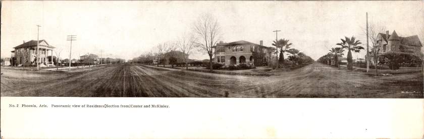
The second view shifts to Phoenix’s growing residential district at Center and McKinley. Here, successful merchants and professionals built impressive homes along wide, unpaved streets. Both palm trees and deciduous trees (some leafless in winter) frame the elegant residences.
These neighborhoods developed as streetcar suburbs, allowing prosperous residents to escape downtown congestion while maintaining business access. Homes display fashionable Colonial Revival and Craftsman styles with generous porches and elaborate details. Unlike cramped eastern cities, Phoenix boasted detached homes on spacious lots—a pattern that would define its future growth.
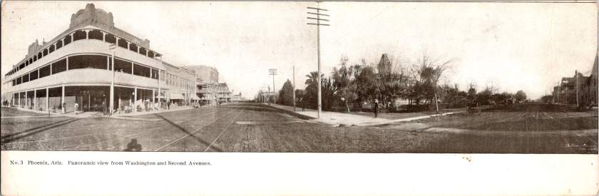
Washington and Second Avenues
The third panorama returns us to the commercial district. A substantial three-story building with multiple balconies dominates the left side. Was it a hotel or major retailer? Streetcar tracks again slice through the broad dirt roadway. A park or green space appears across the street, providing rare desert shade.
Notice the shadow intruding on the lower left? It’s the silhouette of our photographer with tripod-mounted camera. Was this F.J. Bandholtz, a prominent panoramic photographer who worked with Haines?
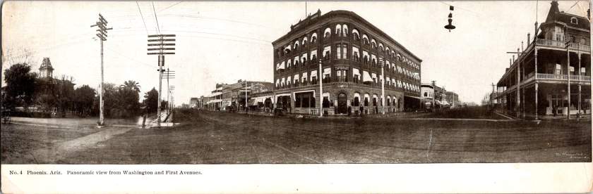
Washington and First Avenues
The fourth panorama captures Phoenix’s financial center. A four-story brick building with numerous arched windows dominates the scene. This building houses the Phoenix National Bank with law offices above, very likely belonging to Joseph H. Kibbey, a former Territorial Supreme Court Justice (1889-1893) and Arizona Territorial Governor (1905-1909).
Founded in 1892, the Phoenix National Bank had become Arizona’s largest by 1899, with deposits totaling $692,166. Telegraph and electrical poles with multiple crossbars line the street, demonstrating developing infrastructure. The dirt streets accommodate both pedestrians and horse-drawn vehicles, though automobiles were beginning to appear.
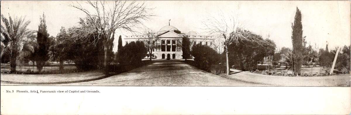
Capitol Grounds
The fifth panorama showcases Arizona’s territorial capitol. This impressive domed structure, completed in 1900 at a cost of $130,000, sits back from the road on a donated 10-acre plot at Washington Street’s western end. Formal gardens with cypress, palms, and ornamental plantings surround the building, irrigation transforming these arid landscapes.
Governor Murphy dedicated the building on February 25, 1901. At the time, the capitol complex embodied Phoenix’s civic ambitions and push toward statehood. Now the main building is home to the Arizona Capitol Museum, connecting present-day Phoenix to its territorial roots.
Phoenix Indian School
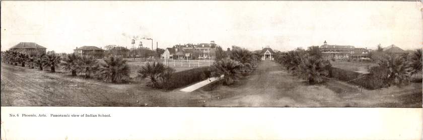
The final panorama depicts the Phoenix Indian School campus with its multiple buildings, some with smoking chimneys, surrounded by palm trees. Established in 1891, this federal boarding school implemented the government’s brutal and coercive Native American assimilation policies. Located on 160 acres north of downtown, the campus featured brick and frame buildings for classrooms, dormitories, workshops, and administration.
The school expanded rapidly from 42 students initially to 698 by 1900, representing 23 tribes from across the Southwest. Operating until 1990, the school’s complex history reflects the often painful relationship between the federal government and Native peoples, and Phoenix’s role in executing national policies.
The Haines Photo Company
These remarkable panoramic images came from the Haines Photo Company of Conneaut, Ohio. From 1908 for about a decade, they specialized in wide-angle photography of towns and cities across the United States. The Library of Congress preserves over 400 of their photographs documenting America’s evolving landscapes and cityscapes.
Technological innovations in cameras and film made panoramic photography possible. Companies like Haines used specialized equipment to capture expansive views with exceptional clarity. They printed these as postcards for both tourists and locals proud of their developing communities. The panoramic format perfectly suited sprawling western cities like Phoenix that grew horizontally rather than vertically.
Who actually pressed the shutter remains mysterious. The Library of Congress identifies F.J. Bandholtz (Frederick J. Bandholtz, born circa 1877) as a prominent panoramic photographer working with Haines. The shadow in the third image provides our only glimpse of the person behind the camera—a tantalizingly incomplete clue to their identity.
Fast Growth in Phoenix
The early 1900s transformed Phoenix through several key developments. Roosevelt Dam (completed 1911) secured reliable water and power for the Valley. The Santa Fe, Prescott and Phoenix Railway (1895) connected the city to northern Arizona while streetcars improved local mobility. Institutions like the Carnegie Free Library (1908) and Phoenix Union High School (1895) established cultural foundations. Economic activity diversified beyond the “Five Cs” (copper, cattle, climate, cotton, and citrus) to include banking, retail, and professional services.
Statehood on February 14, 1912 elevated Phoenix’s status as capital. These postcards hint at those century-old aspirations—a frontier town rapidly becoming a modern American city. Phoenix’s population doubled from 5,554 in 1900 to 11,134 by 1910, and surged to 29,053 by 1920, launching a growth trajectory that would eventually make it one of America’s largest cities.
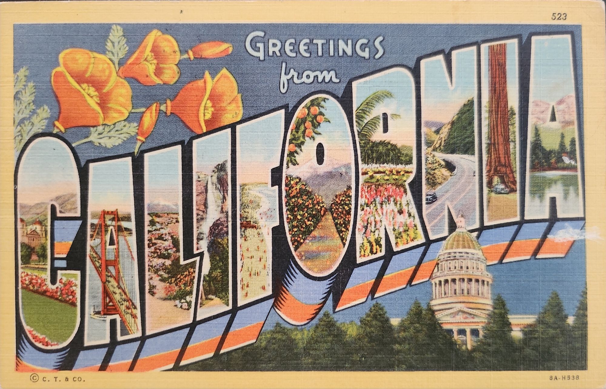
‘Greetings from…’ designs have rippled through visual culture for well over a century, telling the stories of how we see ourselves and our places.
A stone dropped into still water creates concentric circles that radiate outward. This physical phenomenon is a powerful metaphor for how cultural ideas spread through time and across media, especially visual motifs of place. Certain visual vocabularies persist, evolving with technologies while maintaining essential characteristics.
American statehood, regional identity, and natural heritage have rippled through various media over the past century. Iconic ‘large letter’ postcards, commemorative postal stamps, murals and more—all help us trace a fascinating journey of cultural transmission through the broader currents in American history, industrial development, and visual communication.
Gruss Aus… from Germany
“Greetings From…” postcards emerged in 1890s Germany. The early examples of Gruss Aus cards featured the name of a location rendered in bold, three-dimensional letters with miniature scenes of local landmarks contained within. More common postcards of the day feature detailed illustrations of castles and later photographs. This new design cleverly packed maximum visual information into the limited space, creating an instantly recognizable format that would soon spread internationally.
New American Icons
The transmission of this visual language to America came through a German immigrant named Curt Teich, who arrived in the United States in 1895. After establishing his printing company in Chicago in 1898, Teich would transform American visual culture through the mass production of postcards. Following a visit to Germany in 1904, he successfully imported the Gruss Aus style to the American market, adapting it to suit American sensibilities and landscapes.
The true flowering of Teich’s vision came in 1931 with the introduction of his linen-textured postcards. Printed on high-quality paper with a distinctive fabric-like texture, these cards employed vibrant colors and airbrushing techniques that created a hyperreal aesthetic. The technical innovation of the linen card allowed for faster drying times and more saturated colors, resulting in postcards that depicted America in an optimistic, idealized light—a stark contrast to the harsh realities of the Great Depression era in which they first appeared.
Teich’s business savvy was as important as his technical innovations. He employed hundreds of traveling salesmen who photographed businesses and worked with owners to create idealized images for postcards. This approach not only generated business but also shaped how Americans visualized their own landscapes and communities. The Curt Teich Company would eventually produce over 45,000 different linen postcard subjects in just two decades.
The visual language of these postcards—bold lettering, vibrant colors, and idealized scenes—became firmly embedded in American visual culture during the 1930s through 1950s. As automobile ownership increased and the highway system expanded, these postcards played a crucial role in shaping Americans’ understanding of their own geography and national identity. They were both records of places visited and aspirational images of places to be seen.
State Birds and Flowers
Parallel to the development of the large letter postcard, another form of state-based visual identity was taking root—the formal designation of state birds and flowers. Most American states adopted these symbols between the 1920s and 1940s, often through campaigns involving schoolchildren, women’s clubs, and conservation organizations.
These officially designated natural symbols provided another vocabulary for expressing regional identity, one rooted in the natural world rather than the built environment. While large letter postcards typically highlighted human achievements—city skylines, hotels, roadways—state birds and flowers emphasized the distinctive natural heritage of each region. Together, these complementary systems of regional representation provided Americans with a rich visual language for their diverse nation.
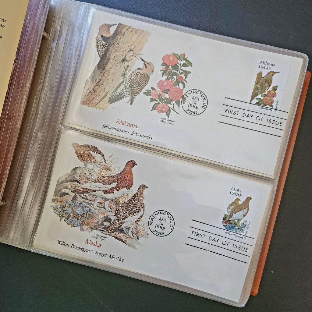
In 1978, the Fleetwood company commissioned father-son wildlife artists Arthur and Alan Singer to create 50 original paintings of state birds and flowers. These watercolor paintings caught the attention of U.S. Postal Service officials, who recognized their exceptional quality and decided to feature them on commemorative stamps. Released on April 14, 1982, the 20-cent State Birds and Flowers stamp collection was another big moment in the ripple effect.
Arthur Singer painted the birds while his son Alan rendered the flowers, creating unique artwork for each of the 50 stamps. The collaboration between father and son added another dimension to this cultural transmission—the passing of artistic traditions and approaches from one generation to the next.
The Fleetwood company published a complete album featuring First Day Covers of these stamps. These decorative envelopes included additional information about each state’s natural heritage, creating a beautifully bound volume that was both aesthetically pleasing and informative. The Birds & Flowers of the 50 States album is now a cherished collectible, a visual catalog of national natural heritage in a single, beautifully presented format.
Greetings from the Post Office
Twenty years later, the visual language of the large letter postcard experienced a revival through another stamp collection. On April 4, 2002, the USPS issued the ‘Greetings from America’ stamps, designed by Richard Sheaff and illustrated by Lonnie Busch. These stamps paid direct homage to the large letter postcards of the 1930s and 1940s, recreating their distinctive style for a new generation.
Each of the 50 stamps featured the name of a state in large, three-dimensional letters containing images of iconic landmarks and scenic vistas. The stamps were initially released as 34-cent denominations, but due to a rate change, they were reissued with 37-cent denominations on October 25, 2002. Here is another circular moment—a postal medium paying tribute to a postcard tradition that had itself been a popular means of commemorating places visited.
These stamps connected with older Americans who remembered the original postcards. Younger generations encountering the style for the first time recognized both the nostalgic and contemporary appeal. The vibrant colors and bold, three-dimensional lettering still effectively communicated a sense of place and regional pride, proving again the resilience of this visual vocabulary.
Even Larger Letters
Artists Victor Ving and Lisa Beggs took the large letter postcard to a whole new scale. Starting in 2015, the Greetings Tour has produced dozens of murals that transform the two-dimensional postcard design into monumental public art.
A grand dimensional leap—a design meant to be held in the hand scaled to the size of a building. The murals maintain the core visual elements of the large letter design while incorporating contemporary references and local touchstones. In a delightful twist, these murals have themselves become tourist attractions with visitors posing for social media. The postcard mural is now a backdrop for new images to be shared globally.
The artists also create custom digital designs for corporations, events, and retail spaces, maintaining the vintage aesthetic while adapting it to contemporary contexts. This commercialization represents another ripple in the cultural transmission of the large letter design, as it moves from public art back into the commercial realm that originally produced the linen postcards.
Digital Doppelgangers
As graphic design software became increasingly sophisticated and accessible in the late 20th and early 21st centuries, the visual language of large letter postcards found new life in digital recreations. Graphic design tools enable designers to quickly recreate the distinctive three-dimensional lettering and image-filled characters of the classic postcards.
AI Generation
Online design platforms have further opened access to this aesthetic, offering templates that approximate the large letter style without requiring specialized skills. Now small businesses, community organizations, and individuals can incorporate elements of this visual tradition into their communications, expanding the reach of this design vocabulary beyond professional designers.
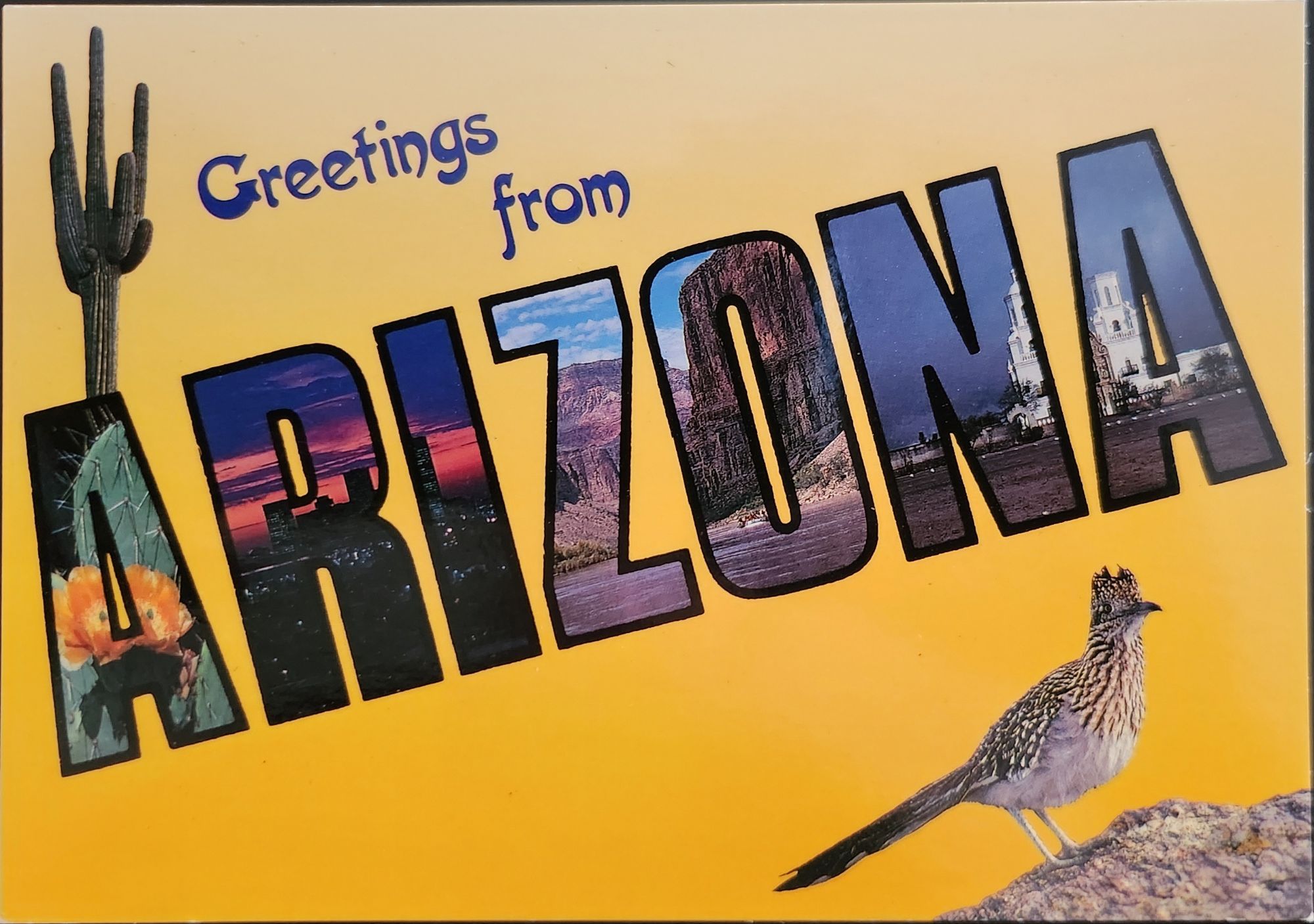
With a phrase like “create an image of a vintage large letter postcard from Arizona,” most anyone can generate a decent design in seconds. Like the old days of digital clip-art, the initial attempts lack craftsmanship and historical accuracy. Still, they are a new democratization of this visual vocabulary, making it more accessible to professional designers and enthusiasts alike, though perhaps for different reasons.
This latest development completes a fascinating loop—from specialized industrial printing processes that required substantial investment and technical expertise, to digital design tools requiring professional training, to AI generation requiring only the ability to formulate a design concept and the text prompt. With each technological advancement, the barriers to producing these distinctive visual representations have lowered, while the core elements of the design has persisted.
Visual Persistence
From German Gruss Aus postcards to AI-generated images—our journey demonstrates the remarkable resilience of certain visual vocabularies across time, technologies, and cultural contexts. Despite dramatic changes in production methods, from specialized lithographic presses to neural networks, the essential visual grammar of these designs remains recognizable.
This persistence has a woven quality—the ability to render and replicate a sense of place over time. Whether in linen postcards, commemorative stamps, public murals, or digital images, the large letter design and state symbol motifs combine to convey regional identity and pride over time. Their continued relevance suggests that certain visual solutions, once discovered, become an architecture that generations continue to appreciate and adapt for new uses.
We also feel the ripple effect in the broader patterns of American history— immigrants bringing skills and technology to American shores, industrial innovation creating new visual possibilities, the automobile age changing how Americans experienced nature and themselves, and digital technology transforming how we create and share images. Through it all, the distinctive visual language pioneered by Curt Teich and others continues to evolve.
What new ripples lie ahead? Perhaps augmented reality will allow us to step into these designs. Or new materials and technologies will adapt them yet again for uses we don’t yet comprehend. Whatever comes next, we know that cultural transmission does have a distinguishing mark—it ripples outward in both calculable and unexpected ways, influenced by technology, economics, and human inspiration, creating patterns that can be traced across generations.
For Additional Reading
Meikle, Jeffrey L. (2016). Postcard America: Curt Teich and the Imaging of a Nation, 1931-1950. University of Texas Press. Publisher’s page
“The Immigrant Story Behind the Classic ‘Greetings From’ Postcards.” Smithsonian Magazine. (2018). Read online
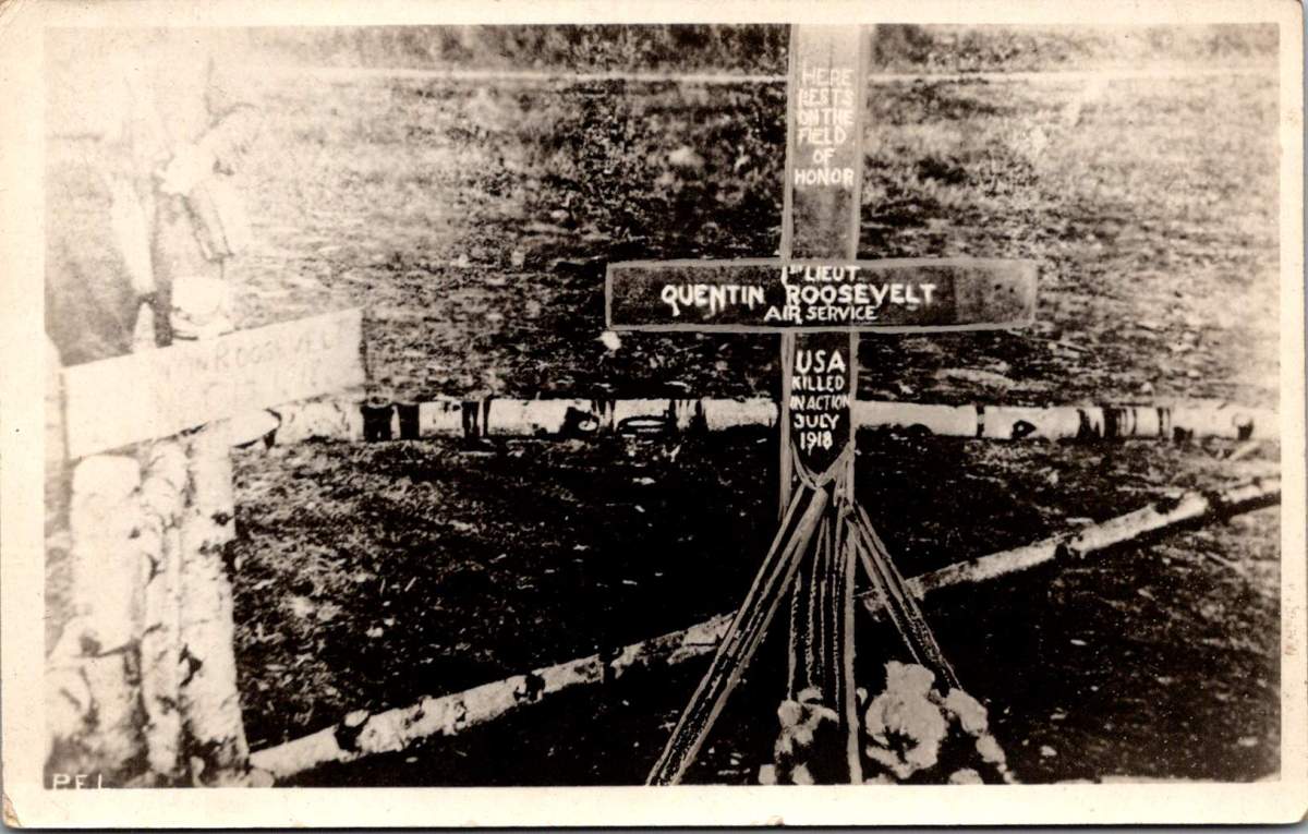
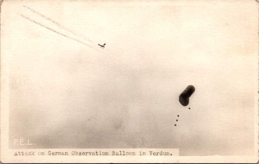
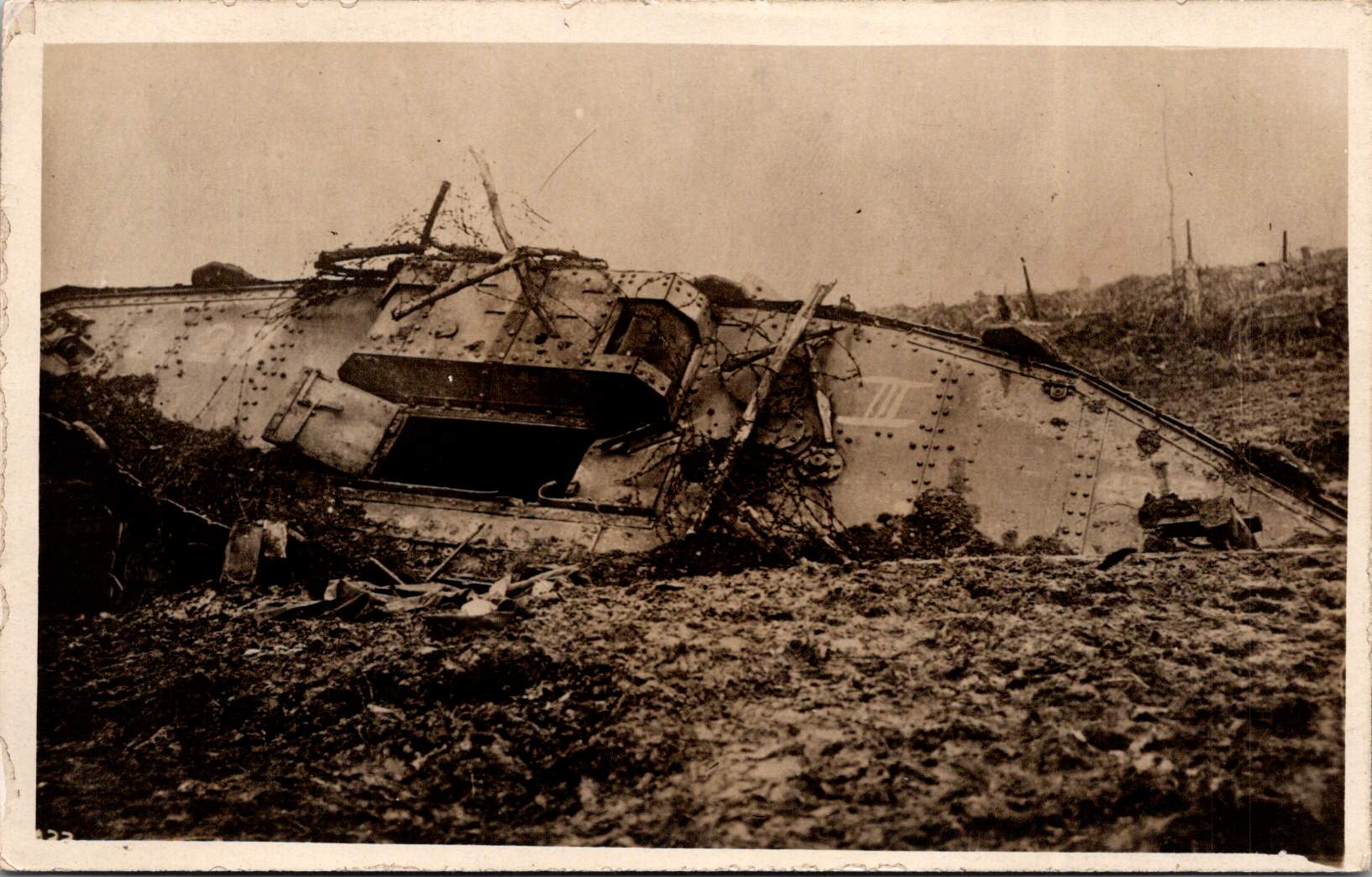
A wooden cross rises from churned earth, the inscription stark against weathered wood. A familiar image of a striking handmade monument to the son of a president who fell from the sky over France.
This photograph, captured by a U.S. Signal Corps photographer known only by the initials P.E.L., embodies the US vision of the first World War carefully curated by military officials. While this image evokes sacrifice, honor, and patriotism, the ones that follow emphasize air power and the ground fight.
The Signal Corps photographers worked with clear directives. Their images showcased military capacity and impact: a German observation balloon in flames over Verdun, captured enemy aircraft, and troops dug into the battlefield. These photos celebrated American military achievements while maintaining a safe emotional distance from war’s realities. They framed the conflict as a grand, heroic endeavor of machines and strategy, and no bodies.
Soldier photography told different stories.
World War I marked a pivotal shift in war photography. The conflict erupted during the democratization of the camera, when Kodak’s marketing promise—You press the button, we do the rest—had placed photography in ordinary hands. For the first time, soldiers carried their own cameras to the front. They documented their experiences without oversight, censorship, or propaganda objectives.
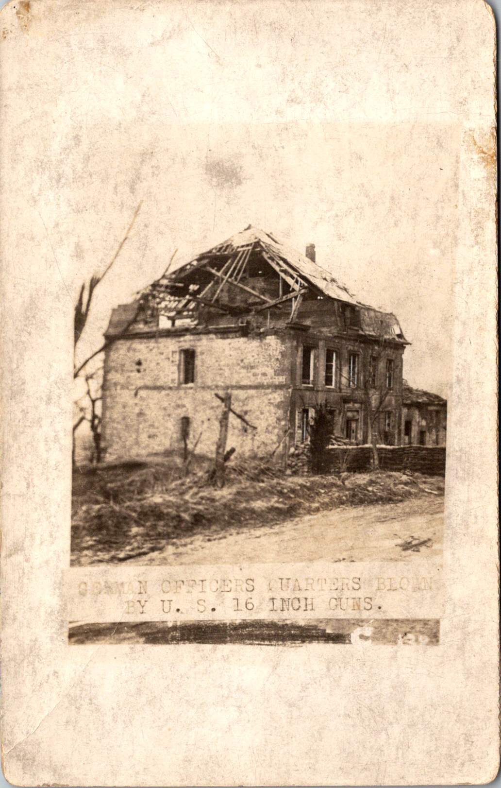
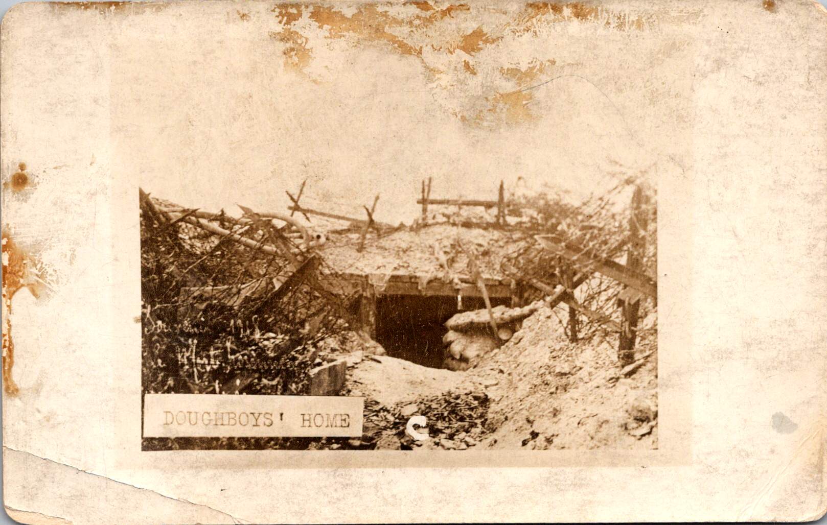
The images captured by troops and printed later at studios like Renfro & Jensen in Belmont, Arkansas reveal a more intimate perspective—the human cost of conflict. German officers’ quarters reduced to rubble by American artillery. The harsh conditions of a foxhole or a machine gun post.
These images weren’t composed for newspaper spreads or government reports. They were personal souvenirs, visual evidence of experiences too enormous to capture in words alone. They were captured on a new-fangled camera and carried home as silent witness.
Belmont, Arkansas transformed virtually overnight in 1917 from a quiet rural community into a bustling military training center. Soldiers flooded the region, bringing with them not just their uniforms and rifles, but their cameras. The town experienced a true boomtown effect as businesses sprang up to serve the influx of military personnel. Among these enterprises, the Renfro & Jensen photography studio established itself as a crucial link between soldiers’ experiences and their communication home.
Then, as demobilization began in 1918, returning soldiers sought ways to share or quietly remember what they had witnessed. Renfro & Jensen became unwitting archivists. They must have developed and printed thousands of soldier photographs—images far more frank and direct than anything appearing in newspapers or government publications. The studio workers were likely among the first civilians to confront warfare through this new technology. Each day, they processed images showing destruction, military achievements, and occasionally, the graphic aftermath of combat. Their commercial service inadvertently preserved a crucial alternative visual history of the conflict.
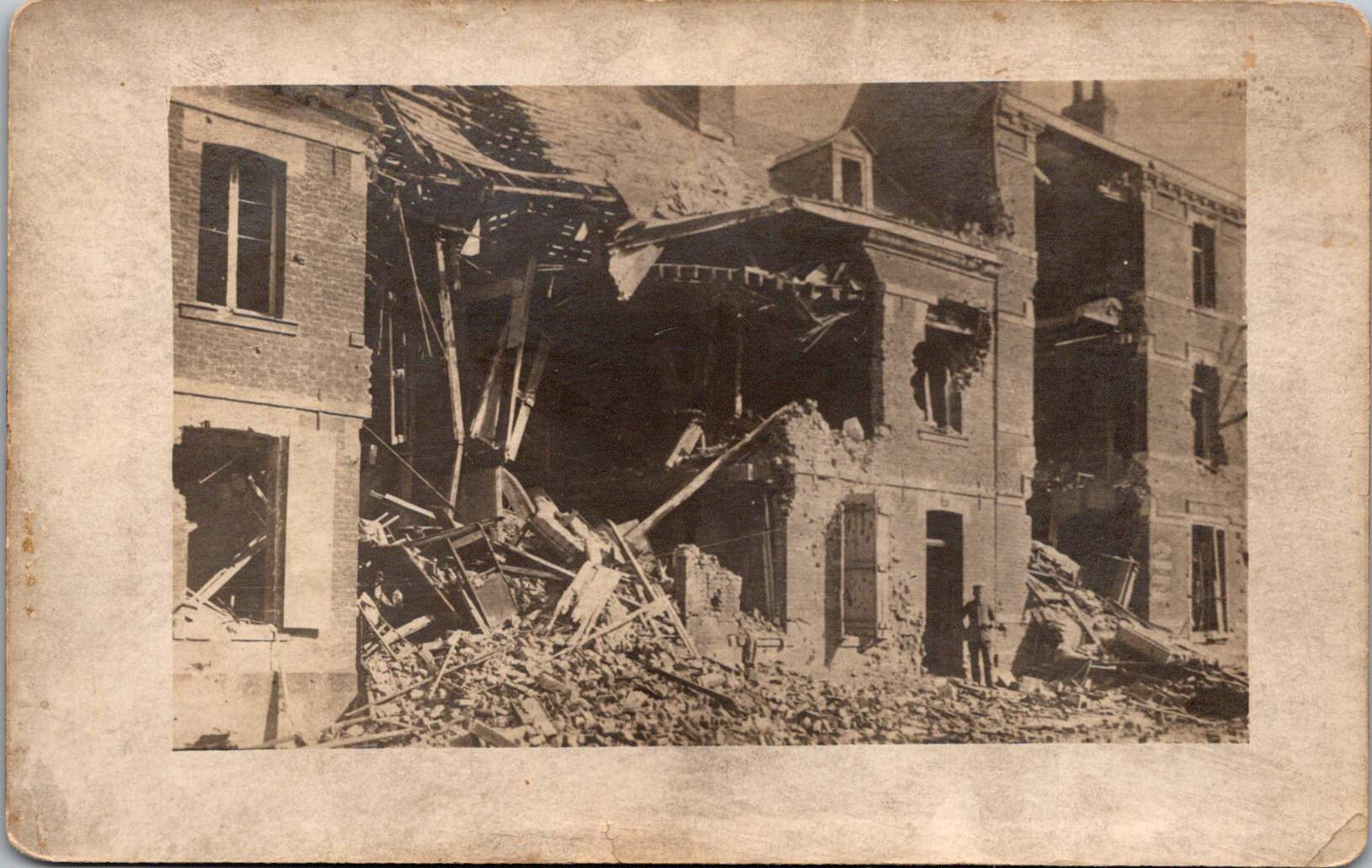
Two European-produced photographic postcards further document the war. These images, printed on distinctive European paper stock, emerged from a continent already numbed by years of destruction.
Another sixteen images — the most harrowing in the collection — can’t be shown here. The ethical boundaries of war photography persist today. What images should be shielded from casual viewing, and which realities deserve documentation regardless of their power to disturb?
Major institutional collections house millions of WWI photographs. The National Archives holds the largest repository of World War I material in the United States, with over 110,000 photographs digitized from two primary series: the American Unofficial Collection of World War I Photographs and the Photographs of American Military Activities. The Library of Congress maintains extensive collections, including the American National Red Cross Collection with over 18,000 digitized negatives showing wartime activities.
Beyond these institutional repositories exists a vibrant world of private collectors who often hold the most provocative and unfiltered images. These private collections sometimes reveal perspectives absent from official archives. Photographer Carl De Keyzer discovered approximately 10,000 archival glass plate and celluloid negatives from WWI scattered across Europe, many in private hands. From these, he selected 100 to reproduce in stunning detail, revealing aspects of the conflict previously unseen in such clarity. Some of the most compelling battlefield imagery exists in small personal collections—albums like this one that have been kept by families of veterans, passed down through generations, their contents rarely exhibited publicly.
The grave of Lieutenant Quentin Roosevelt is quite enough for many. It symbolizes loss while sparing us its visceral reality. But the full photographic record of the conflict includes truly heinous realities—corpses tangled in barbed wire, faces distorted by gas, bodies rendered unrecognizable by artillery.
While official photographers were tasked to frame narratives that supported war efforts, some soldier photographers refused to turn a blind eye. They captured what they witnessed, creating very personal views that continues to challenge our understanding of history. Their lenses documented what words alone could never convey—the irredeemable human cost of modern warfare.
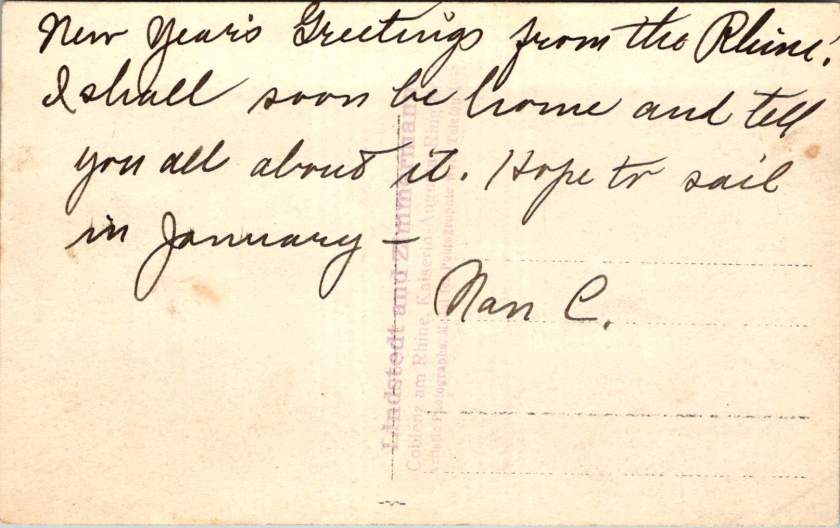
When I connected with European researchers writing a book on the married Swedish/German photographers, Lindstedt and Zimmermann, we discovered that last week’s trove of real photo postcards is quite rare. Even better, we found more.
New Discoveries from a Lost Archive
Last week’s essay examined the American occupation of Coblenz, a unique period of military history, through the photographic lens of Lindstedt & Zimmermann. The Lindstedt & Zimmermann studio was destroyed during Allied bombing in World War II, decimating their archive and rendering the surviving examples of their work as uncommon historical artifacts.
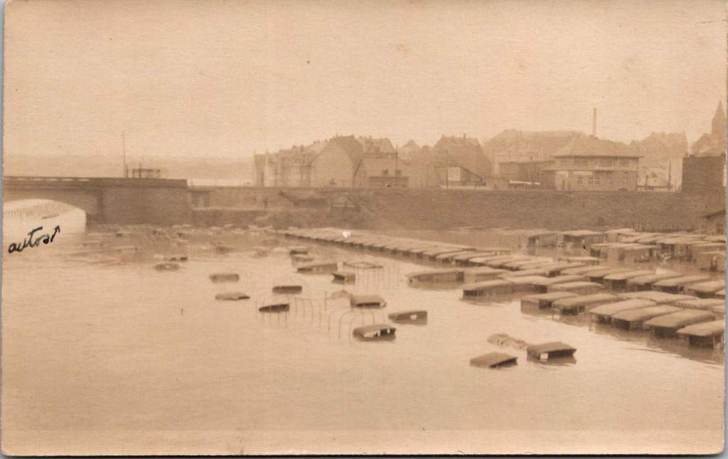
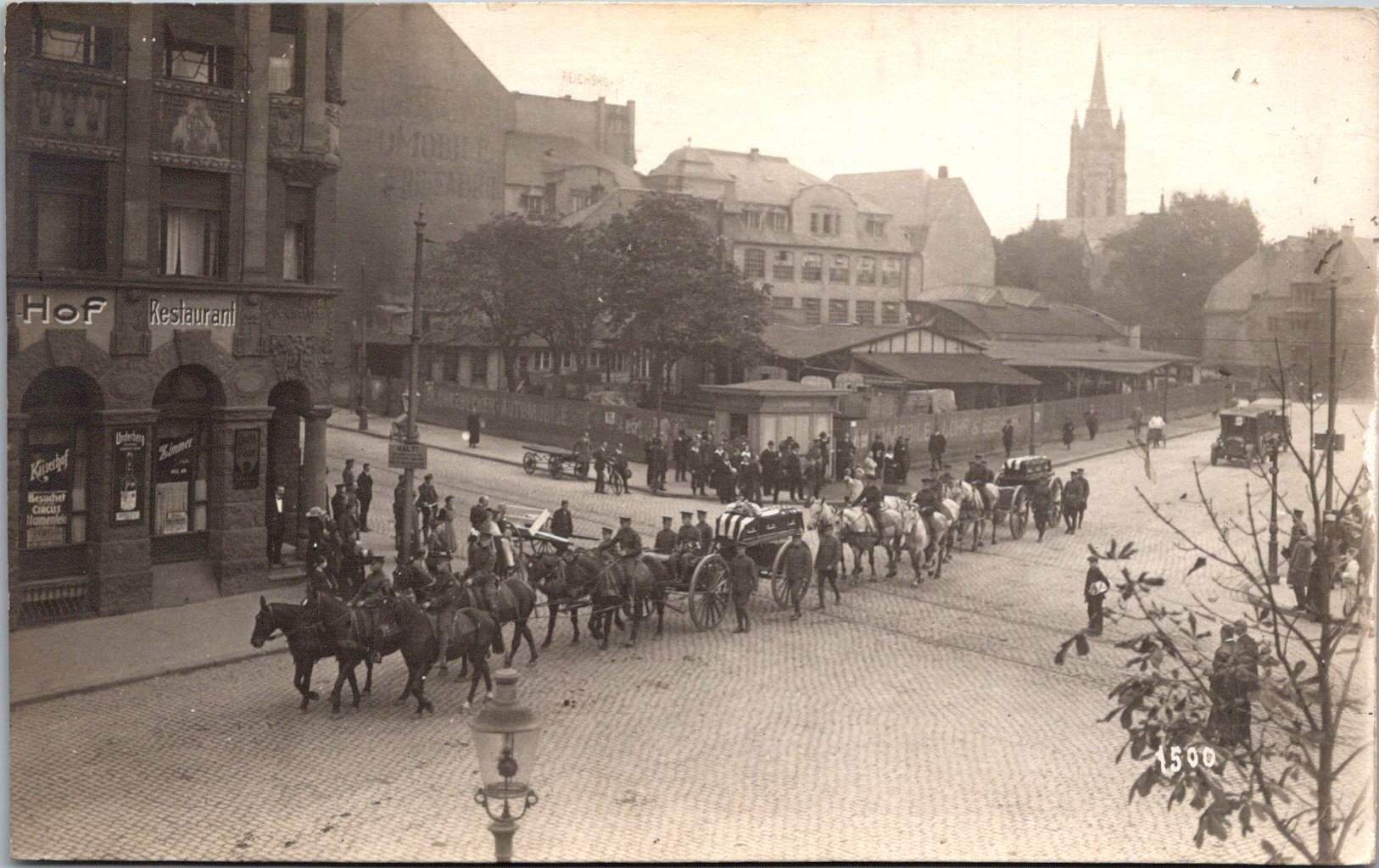
The exchange with the research team prompted another search through our postcard collection resulting in the discovery of 25 additional images. Most can be attributed to Lindstedt & Zimmermann based on stylistic elements, materials and subject matter. Some bear the mark of other photographers including Paul Stein, another Coblenz studio. Ten photographs document the catastrophic flood of the Rhine in January 1920 – images that likely haven’t been seen in a century.
The Great Flood of January 1920
The January 1920 flood represented one of the most significant natural disasters to impact the American occupation forces during their tenure in Germany. The handwritten note on one postcard reveals both the severity of the flood and its impact on the American presence. This mixed German-English description captures the cross-cultural nature of the occupation.
“Der Rhein hat über its banks geflowed und Uncle Sam’s autos gdamaged. The river is the highest in over a hundred years, almost beyond my memory!”
The photographs show numerous small boats navigating the water and automobiles partially submerged in floodwaters, with bridges and buildings visible in the background. These images provide rare documentation of a significant environmental event that temporarily disrupted occupation activities and required adaptation by both American forces and local residents.
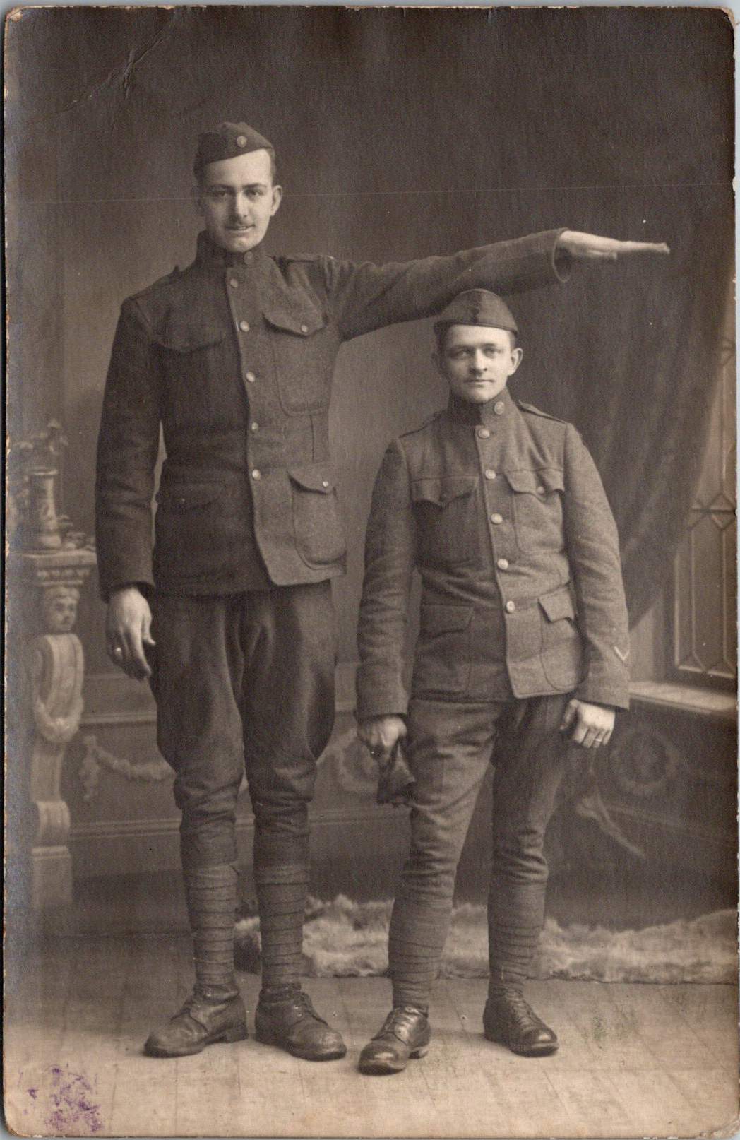
Harlem Hellfighters
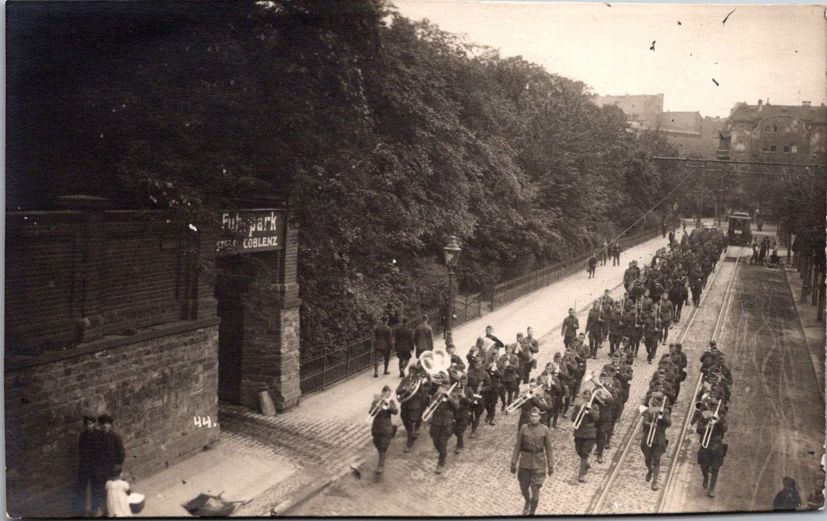
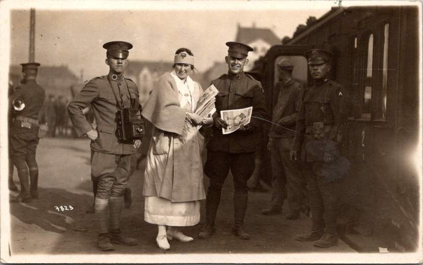
This very rare view shows what appears to be members of an African American regimental band with their instruments at Romagne, France. Black men served in segregated units during World War I, with regiments such as the 369th Infantry (the “Harlem Hellfighters”) earning recognition for their service. Their regimental bands played an important cultural role, introducing European audiences to American jazz and ragtime music. These musical ambassadors created cultural connections that transcended the military context of their presence. The inclusion of this photograph adds an important dimension to our understanding of the American military presence in post-war Europe, highlighting the contributions of African American servicemen whose stories have been marginalized in historical accounts.
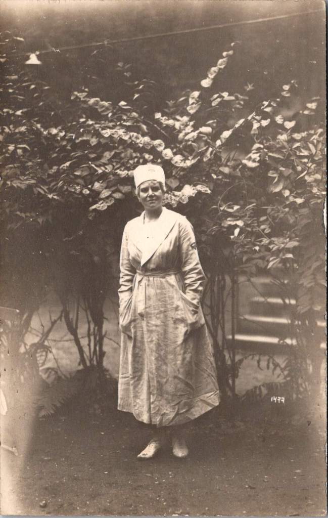
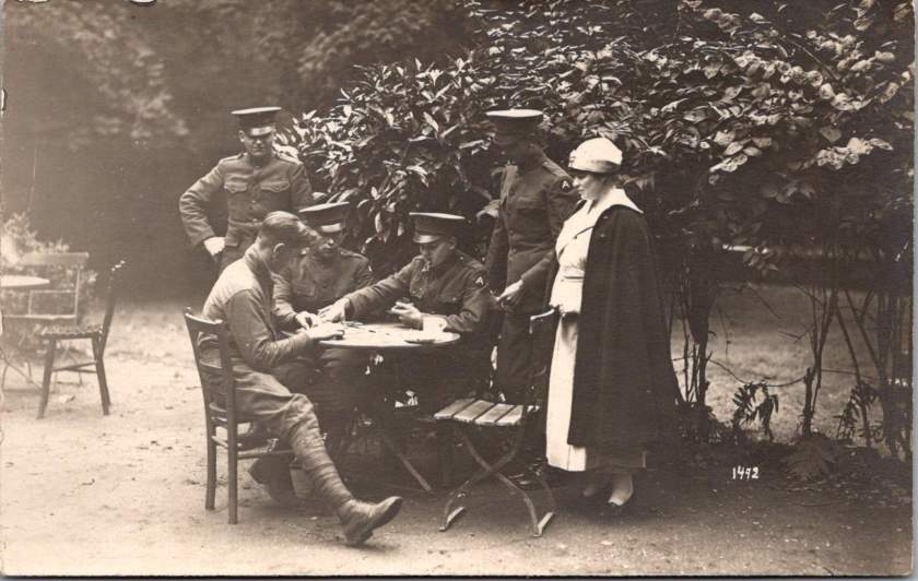
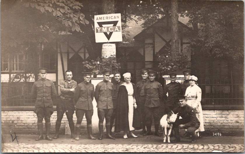
YMCA Women
The expanded collection also includes two formal portraits of women in YMCA uniform, complete with the organization’s distinctive triangular insignia on hat and lapel. Sometimes called Y girls, female YMCA workers provided essential services for American soldiers stationed far from home. They operated canteens, organized recreational activities, offered educational programs, and provided a connection to American civilian life that helped maintain morale during the occupation period.
The YMCA was among the few organizations that deployed American women to work directly with troops overseas during this era. These women volunteers typically came from educated, middle or upper-class backgrounds and represented an early example of American women engaging in international service work. Their presence added a civilian dimension to the occupation and helped create environments where American soldiers could productively spend their off-duty hours.
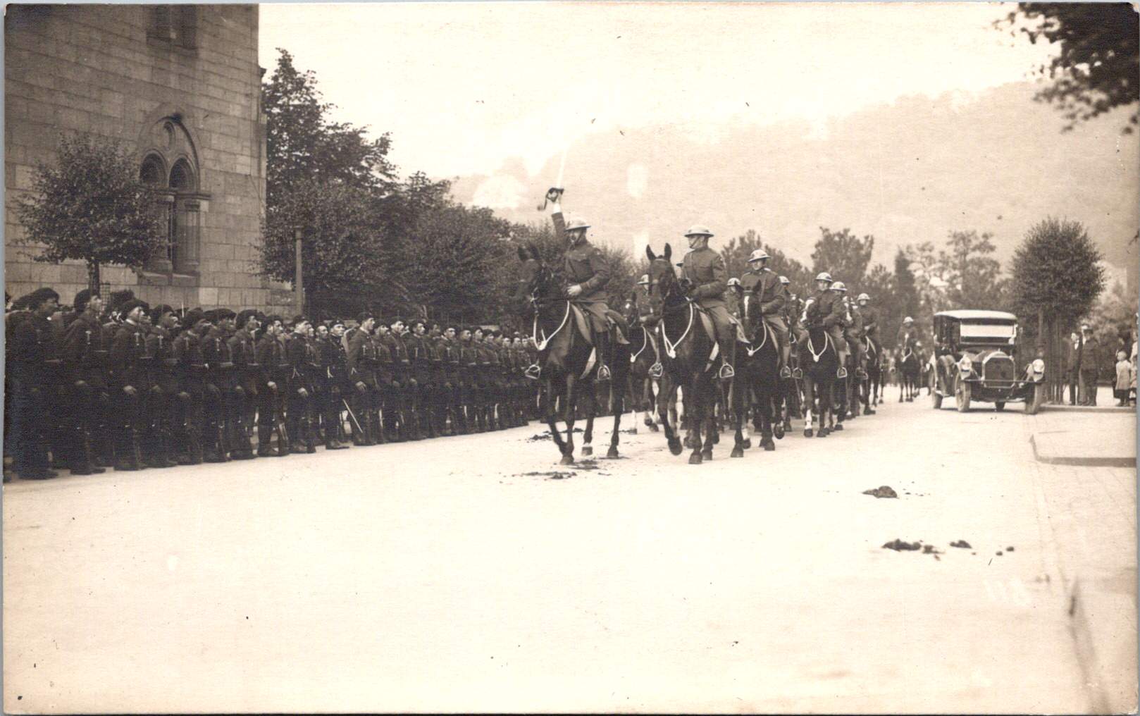
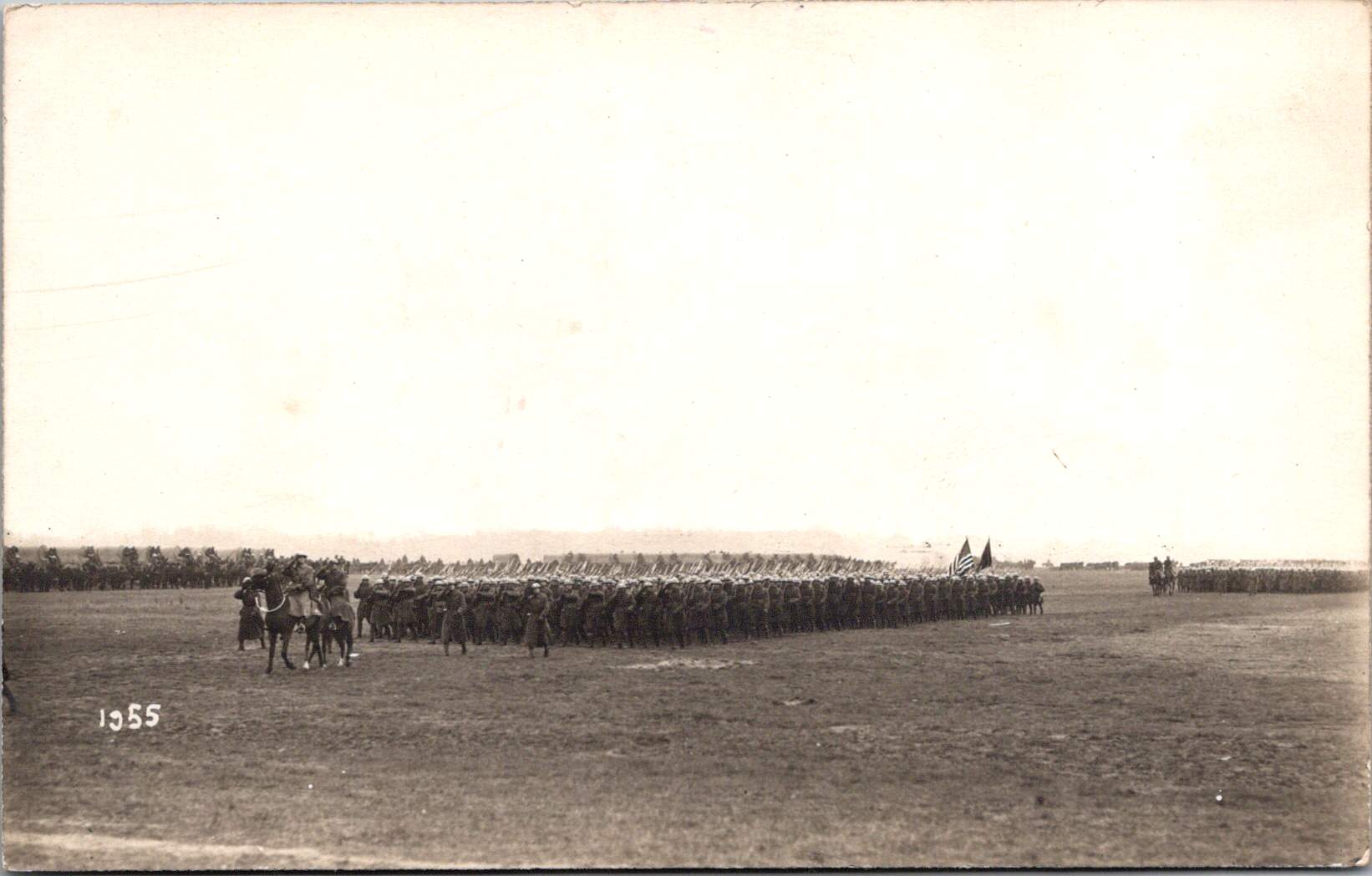
Military Pageantry and Daily Operations
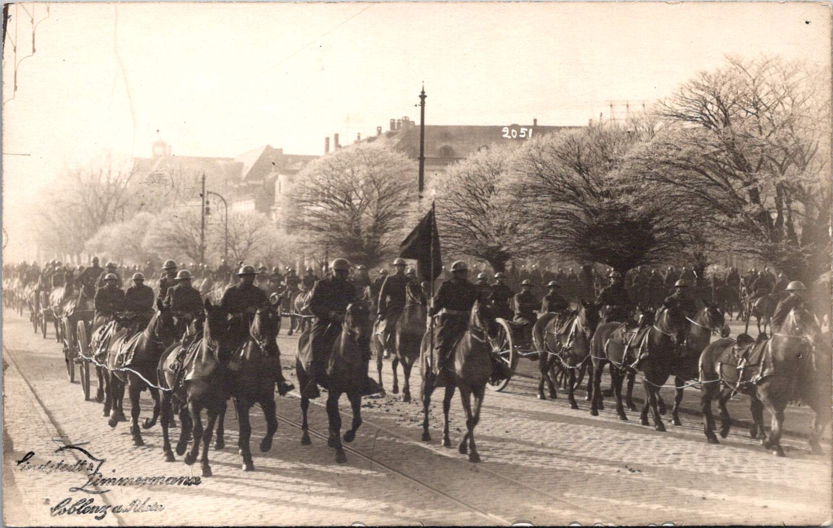
One striking photograph shows the 76th Field Artillery Regiment arranged in a “living insignia” formation, with soldiers positioned to create the unit’s distinctive diagonal striped insignia, surrounded by artillery pieces. This type of military display was meant to demonstrate American capacity while building unit cohesion and pride, and perhaps avert a little boredom.
In contrast to these ceremonial arrangements, other photographs document the practical transportation and logistical elements that supported daily operations. An image of a young driver with his heavy-duty truck along what appears to be the Rhine riverbank represents the essential supply operations that maintained the American presence. The vehicle’s utilitarian design with solid rubber tires, wooden spoke wheels, and large cargo bed illustrates the practical equipment used to transport supplies, equipment, and personnel throughout the occupation zone.
French Military Presence
The next image shows a group portrait of four French soldiers in their distinctive uniforms. Easily identified by their characteristic “Adrian” helmets with the prominent crest ridge along the top and the horizon blue (bleu horizon) uniform that became emblematic of French forces during World War I, these men represent the broader Allied presence in post-war Germany.
France maintained the largest occupation zone in the Rhineland, reflecting their particular security concerns regarding Germany. French forces occupied territories including Mainz, while American forces centered on Coblenz and British forces on Cologne. Later, French forces took over the Coblenz occupation.
The portrait format was typical of military mementos during this era, allowing soldiers to document their service and send images to family members. The survival of any images at all is due to this distribution by soldiers to their home countries.
Beyond Coblenz
Not all images in the collection were taken in Coblenz itself. One photograph shows American personnel in a touring car filled with passengers in what may be the French Riviera, identifiable by its distinctive palm trees and Mediterranean architecture. Dating to 1921-1923 based on the automobile’s style, this photograph represents the recreational opportunities available to some American personnel during leave periods from their occupation duties.
Europe allowed for cultural and recreational experiences that would have been impossible for most Americans of this era. For many young Americans serving in the occupation forces, this European assignment represented their first—and perhaps only—opportunity to experience the wider world beyond their home communities.
Visual Legacies
The survival of these photographs, particularly those documenting the 1920 flood, represents a remarkable preservation of visual history that might otherwise have been lost entirely. With the bombing of the Lindstedt & Zimmermann studio during World War II, the unique nature of real photo postcards, and the general fragility of materials from this era, each surviving image offers a rare window into this formative period in world relations.
Karl and Änne Zimmermann’s work, along with that of contemporaries like Paul Stein, provides an invaluable visual chronicle of the first American occupation of European territory—a precedent for the much larger American military presence that would emerge in Europe after World War II. Their photographs capture not just military operations and formal events but the daily reality of cross-cultural interaction between Americans, French, and Germans during this unique historical moment and place.
A Swedish-German photography team documented America’s occupation in Coblenz after World War I.
Coblenz (now Koblenz), situated strategically at the confluence of the Rhine and Moselle rivers in Germany, has experienced numerous military occupations throughout its long history. The city’s geographic importance as a crossing point and defensive position made it a coveted location for military powers across the centuries.
Dating back to Roman times, when it was known as Confluentes, the settlement served as a military outpost securing Rome’s frontier. Through medieval and early modern periods, Coblenz changed hands repeatedly during Europe’s dynastic conflicts. However, the most significant pre-20th century occupation came during the French Revolutionary Wars and Napoleonic era (1794-1814), when French forces controlled the city for nearly two decades, incorporating it into the French First Empire.
After Napoleon’s defeat, the 1815 Congress of Vienna assigned Coblenz to Prussia. The Prussians recognized its strategic value and constructed the massive Fortress Ehrenbreitstein on the east bank of the Rhine, transforming the area into one of Europe’s strongest defensive positions. This began a century of Prussian, and later German, control that would last until the end of World War I.
US Occupation: December 1918
The American occupation of Coblenz emerged from the terms of the Armistice that ended World War I on November 11, 1918. The agreement stipulated that Allied forces would occupy the Rhineland, with the region divided into three primary zones: American, British, and French. This occupation was designed to ensure German compliance with armistice terms and provide leverage during peace negotiations.
On December 13, 1918, elements of the U.S. Army’s Third Army, commanded by Major General Joseph T. Dickman, crossed the Rhine and officially began the occupation of Coblenz and its surrounding area. By December 17, the American forces had fully established their headquarters in the city, with approximately 240,000 troops in the region, though this number would decrease significantly over time.
Major General Henry T. Allen later replaced Dickman as commander in July 1919, overseeing the majority of the occupation until American withdrawal in 1923.
Unlike France, which had suffered repeated German invasions and maintained historical animosities, American forces approached the occupation with less punitive attitudes. This pragmatic approach, combined with the economic resources American soldiers brought to the local economy, created a relatively stable, though still complex, occupation environment.
A Photographic Partnership
The American occupation of Coblenz coincided with a pivotal period in photographic history, and two photographers were perfectly positioned to document this unprecedented moment: Anna Victoria “Änne” Lindstedt and her husband Karl Zimmermann. By 1918, photography had evolved significantly from its mid-19th century origins, but still required considerable technical expertise. German and Swedish photography had developed along somewhat different paths.
Anna’s photographic journey began far from Germany, in southern Sweden. Born in 1883 in Hörby, Sweden, she was the daughter of J.M. Lindstedt, an established Swedish photographer. Photography in late 19th century Scandinavia was a growing professional field, with Swedish photographers making significant technical advancements. Anna grew up immersed in this environment, learning technical skills in her father’s studio during a period when photography was transitioning from a purely chemical process to a more refined art form. This Swedish background gave her a distinct perspective and technical foundation that would later influence her work in Germany. By the early 1900s, Anna had established her own photography studio in Lund, demonstrating her independence in a field still dominated by men.
Karl Zimmermann established a photography studio in Diez an der Lahn, Germany and was operating in 1914, at the outbreak of World War I. He had developed a reputation for documenting local events and creating portraits, building technical expertise during a period when German photography was gaining international recognition for its precision and artistic innovation.
The couple became engaged in 1916, in the midst of World War I. After the war ended, they merged their photography businesses in Coblenz, recognizing the unique historic and commercial opportunity presented by the American occupation.
The real photo postcard (RPPC) format that Lindstedt and Zimmermann utilized had emerged in the early 1900s, enabled by the development of the postcard backing paper with preprinted postage markings. These allowed photographers to create small edition prints that could be sold commercially and easily mailed.
YMCA in the American Occupation
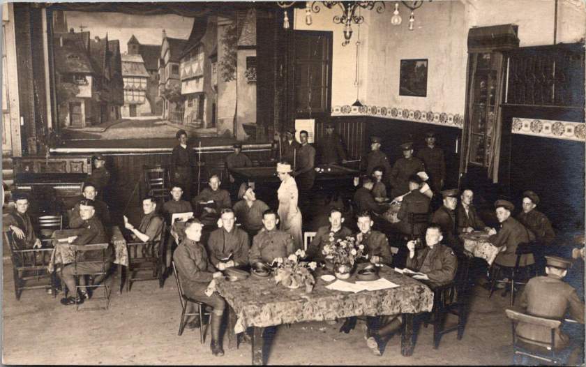
The Young Men’s Christian Association (YMCA) played a crucial role in supporting American troops during the Coblenz occupation. Within weeks of the American arrival, the YMCA established facilities throughout the occupation zone, with their main headquarters in Coblenz itself.
The YMCA’s presence in military zones had been established during the war, but the occupation presented new challenges. Rather than serving troops in active combat, the organization now needed to address the morale and welfare needs of an occupation force facing potential boredom and disciplinary challenges.
By 1920, the YMCA operated approximately 20 centers throughout the American zone. These facilities provided alternatives to less supervised entertainment, offering recreational spaces, reading rooms, educational programs, religious services, and organized athletics. The organization also facilitated cultural exchanges, including German language classes that helped improve relations between American troops and local residents.
YMCA centers became important social hubs for American forces, with thousands of soldiers visiting these facilities daily. The centers also employed a combination of American YMCA staff and local German civilians, creating a rare space for cultural integration during the occupation.
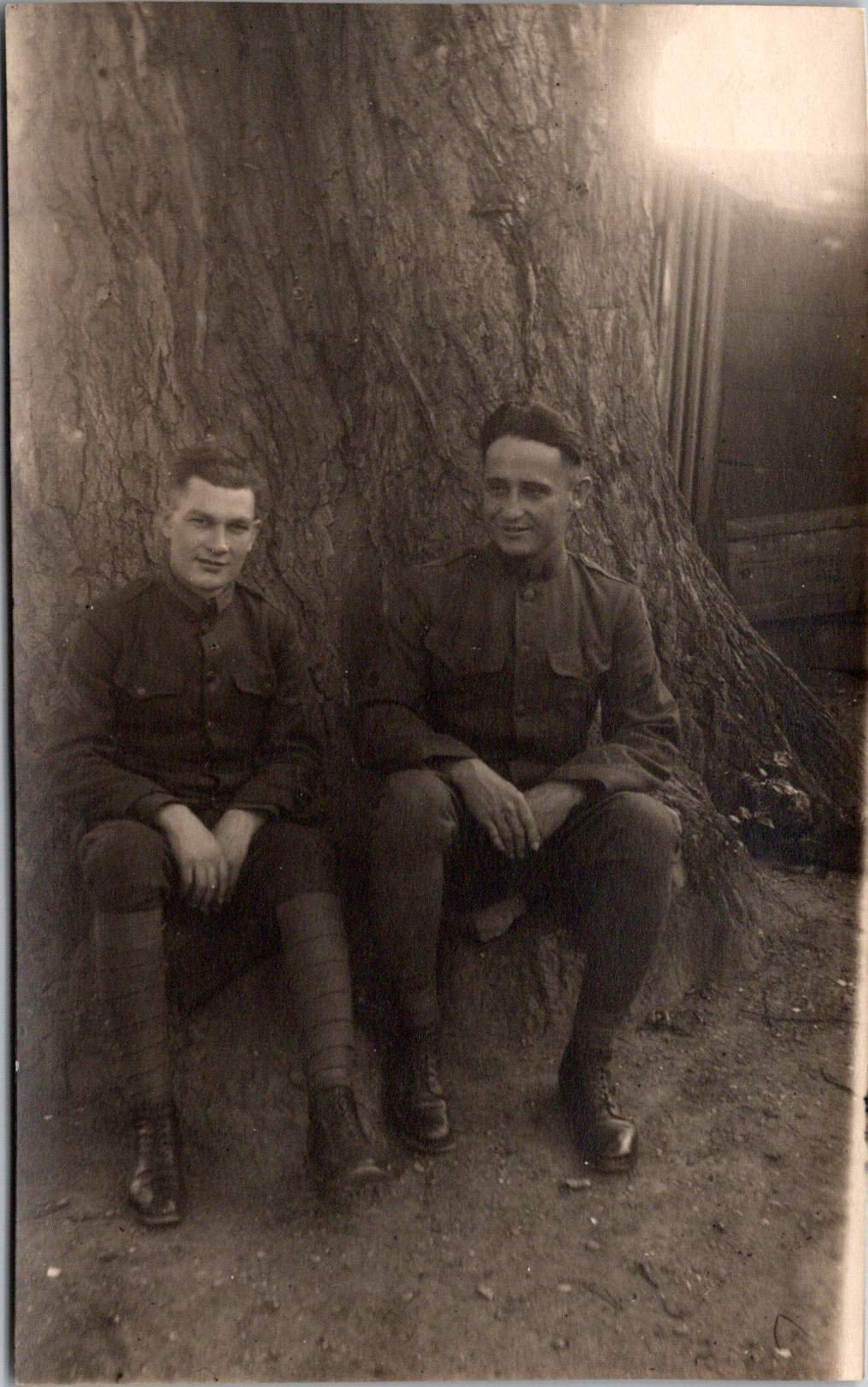
Soldiers’ Experiences
While the broad historical narrative of the American occupation focuses on military units and official policies, individual soldiers’ experiences varied widely. Some troops formed positive relationships with German civilians, while others remained isolated within American enclaves. Some embraced the opportunity to explore European culture; others counted days until their return home.
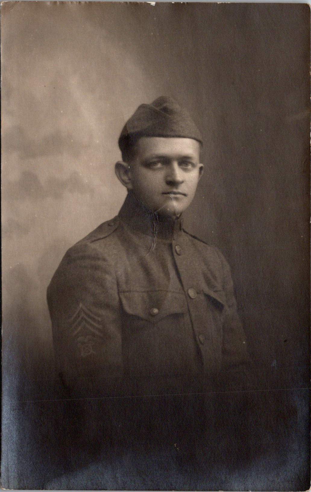
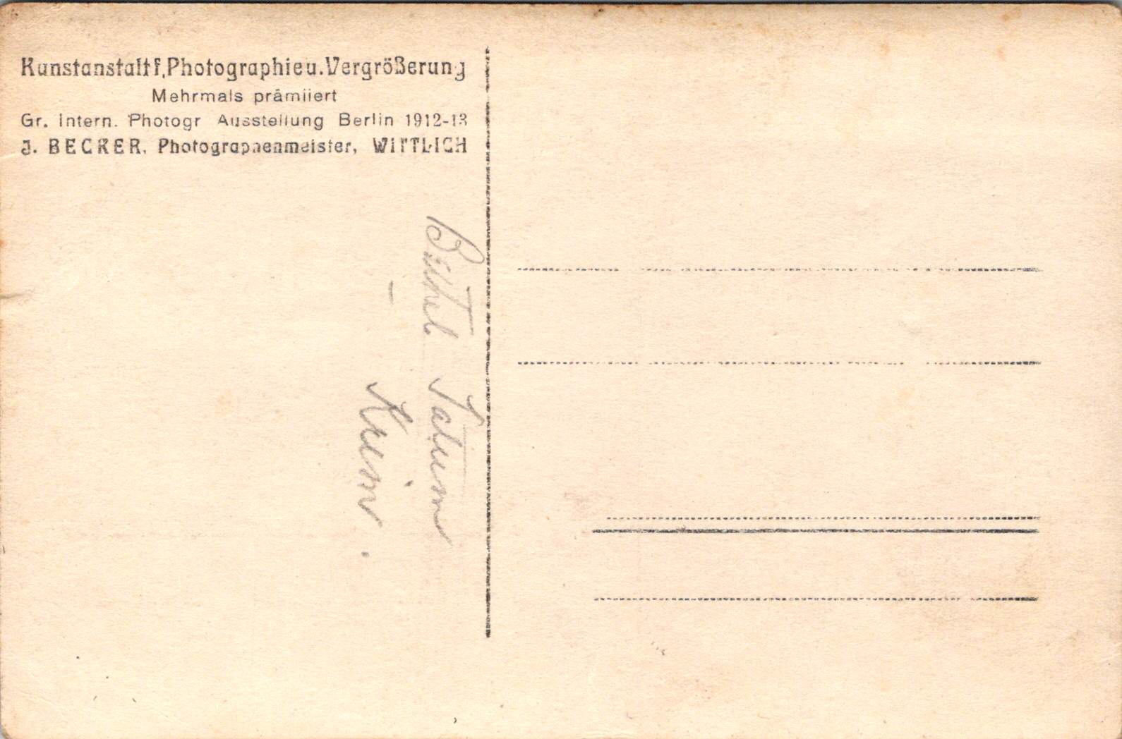
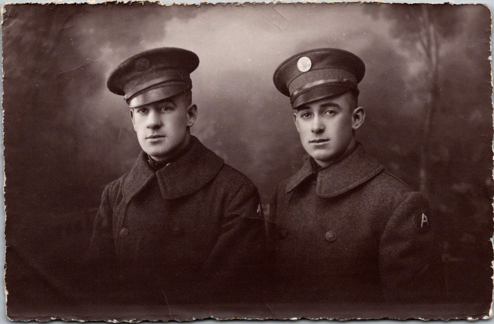
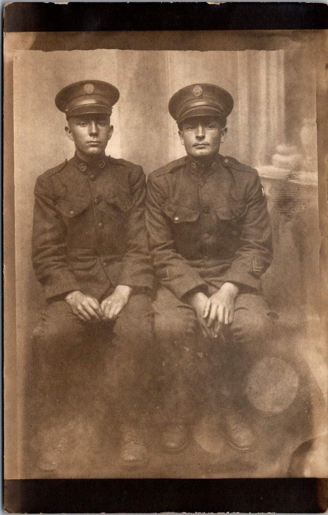
The convenience of real photo postcards can be a barrier in historical research. Only some cards were labeled with names of men — Charles E. Wilson Jr., Norman Page, and Donald Harris pictured here — who were among the thousands of American soldiers who had their portraits made in Coblenz during this period. Bethel Tatum appears in multiple images, as does another anonymous soldier. George Purcell’s military record confirms he received a silver medal for gallantry in action during World War I before serving in the occupation force.
One of the more curious connections involves 328 Chauncey Street in Brooklyn, New York, inscribed as the address for Charles Thomas, who appears in two photos. The same location later became famous as Jackie Gleason’s boyhood home and the fictional address in “The Honeymooners”. There are no known family connections, but this is how rumors begin. Soldier Charles Thomas bears an uncanny resemblance to the comedian star.
Olympic Connections
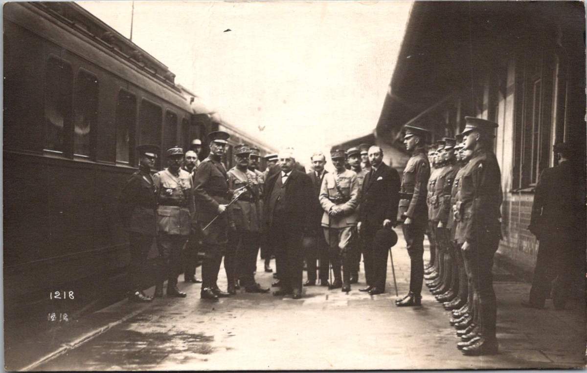
Pierre de Coubertin, founder of the modern Olympic movement, maintained a significant interest in post-war athletic events, including those organized by military forces. As president of the International Olympic Committee until 1925, he worked actively to revive international sporting competitions after the war’s disruption. He may have visited Coblenz on a tour of the Inter-Allied Games in the summer of 1919.
The 1920 Summer Olympics in Antwerp, Belgium—the first Games held after World War I—represented a significant milestone in de Coubertin’s efforts. Karl Zimmermann, who worked for both the US and French forces, may have traveled to Antwerp, and even photographed de Coubertin and General Pershing.
By 1928, Karl’s declining health forced changes to their business operations. Änne became managing director in 1930 and changed the business name to Welt-Foto-Koblenz, perhaps an attempt to broaden their commercial appeal and provide delicate cover for husband’s ailments. Karl’s mental health continued to deteriorate, ending his photojournalistic work by 1934. After his death in 1943 at the Hausen/Wied sanatorium, Änne managed to preserve aspects of their photographic legacy through the war years.
Änne’s post-war life included time between Koblenz and her native Sweden, maintaining connections to both the place where their most significant work was created and her homeland. She died on November 11, 1962, and was buried in the new cemetery in Åhus, Sweden, bringing her remarkable photographic journey full circle.
A Photographic Legacy
The Lindstedt and Zimmermann postcards documenting the American occupation of Coblenz represent an important visual historical record of this significant period. These images provide insight into a unique moment when American forces first occupied European soil—a preview of the much larger American military presence that would emerge in Europe after World War II.
Their work serves multiple historical functions: documenting military operations, capturing cultural exchanges, preserving individual experiences, and recording the physical environment of occupied Coblenz. This rare visual archive helps us understand what happened during the occupation, and how daily life unfolded.
Through the combined Swedish-German lens of Lindstedt and Zimmermann, we gain a more nuanced understanding of this complex chapter in American-European relations and the early development of American overseas military presence that would shape the 20th century.
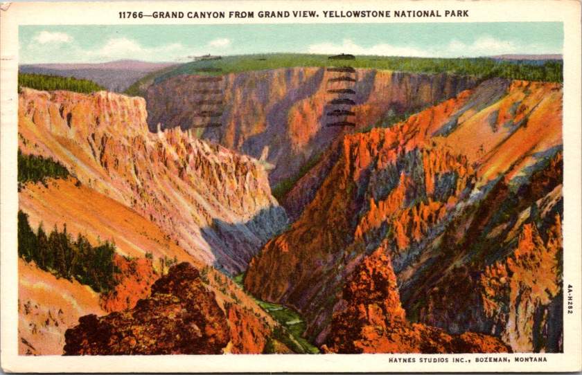
Old Faithful Inn stretches across the Yellowstone landscape, its distinctive roofline echoing the forested hills in a vintage linen postcard. Steam rises from the nearby geyser basin. The Civilian Conservation Corps built Yellowstone for their time and for future generations. In New York, a sister program blazed trails, too.
The story of our national parks is also a remarkable story of resilience and collaboration in hard times. Just as the national parks were becoming popular, the Depression brought unprecedented unemployment and bare scarcities at home, on the farm, and in cities. Leaders with optimistic vision were challenged to engage an illiterate and unskilled workforce or face severe cultural, social, and economic consequences.
The Civilian Conservation Corps’ work in Yellowstone exemplified an unprecedented partnership between federal agencies, orchestrated by a remarkable team. Robert Fechner, the program’s first director, brought his labor union experience to balance competing interests that might have limited the program. Harold Ickes, as Secretary of the Interior, ensured high standards for conservation work. The Department of Labor selected the men for service in the corps. The Army constructed and operated the camps. The National Park Service and Forest Service supervised the technical and construction work. This complex dance of bureaucracy somehow produced remarkable efficiency, with the CCC completing projects that had languished on drawing boards for decades.
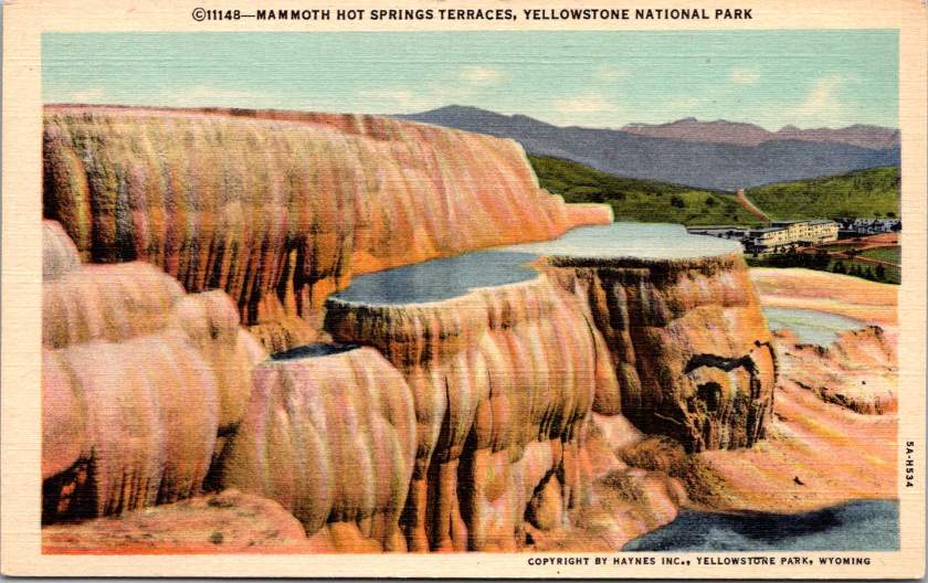
Take the terraced formations of Mammoth Hot Springs, for example, their delicate travertine steps descending the hillside in nature’s own architecture. CCC workers constructed the stone steps and walkways that would allow visitors to safely view these natural wonders. The careful integration of human infrastructure with natural features became a hallmark of CCC work. Now known as ‘parkitecture’, the philosophy would influence park design for generations.
Long before the federal programs, Frances Perkins coordinated closely with Roosevelt during his New York state governorship to protect workers and grow the workforce. She had witnessed the Triangle Shirtwaist Factory fire in 1911, an experience that drove her lifelong commitment to worker safety and labor reform. As New York’s Industrial Commissioner from 1929 to 1933, Perkins pioneered unemployment relief programs and worker protections that would later shape New Deal policies. When Roosevelt became president, he named her Secretary of Labor – the first woman to serve in a presidential cabinet – and she brought her New York experiences to Washington just in time.
Perkins understood the value of both job creation and job training, having seen their impact in New York. She helped shape the CCC, carefully navigating the political tensions around women’s employment programs. Her influence helped ensure that CCC and other programs included educational components, reflecting her belief that economic relief should build long-term capabilities, not just provide temporary aid. She also made sure the federal programs benefited her home state, and piloted important new programs there.
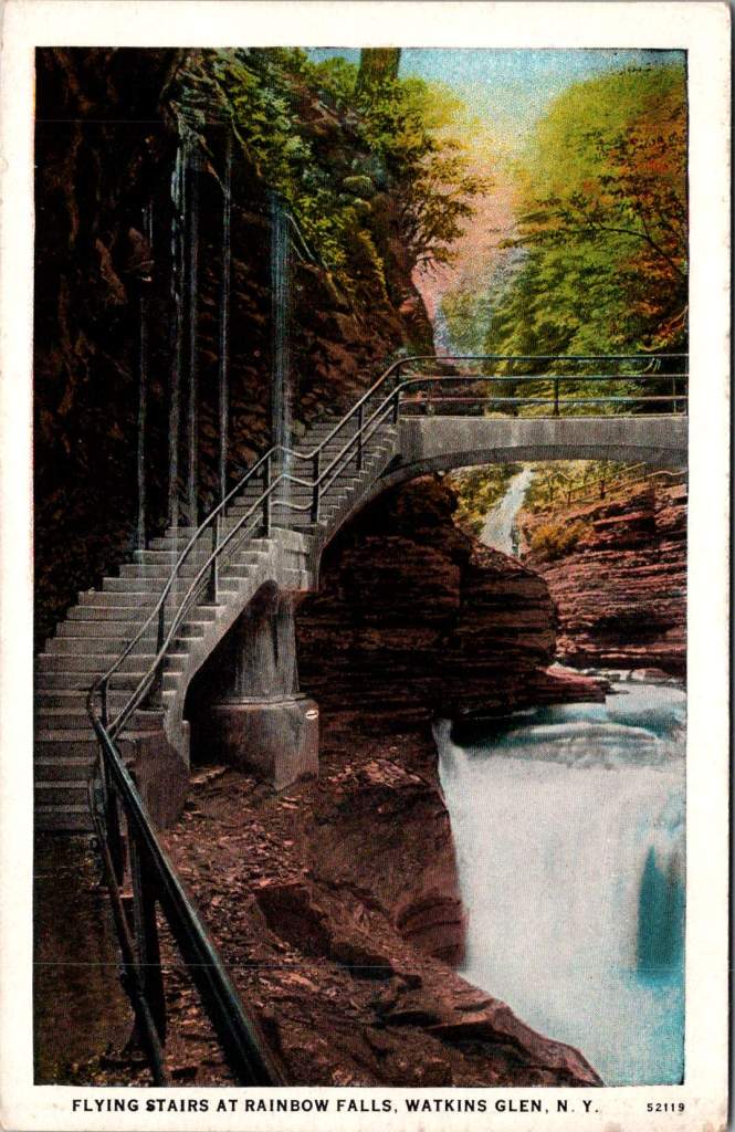
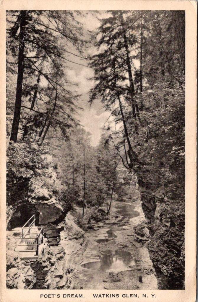
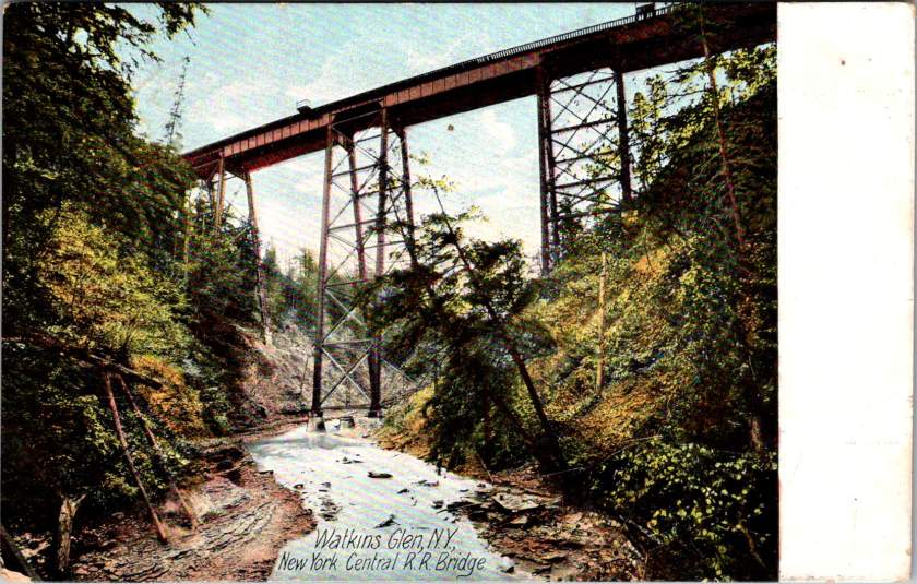
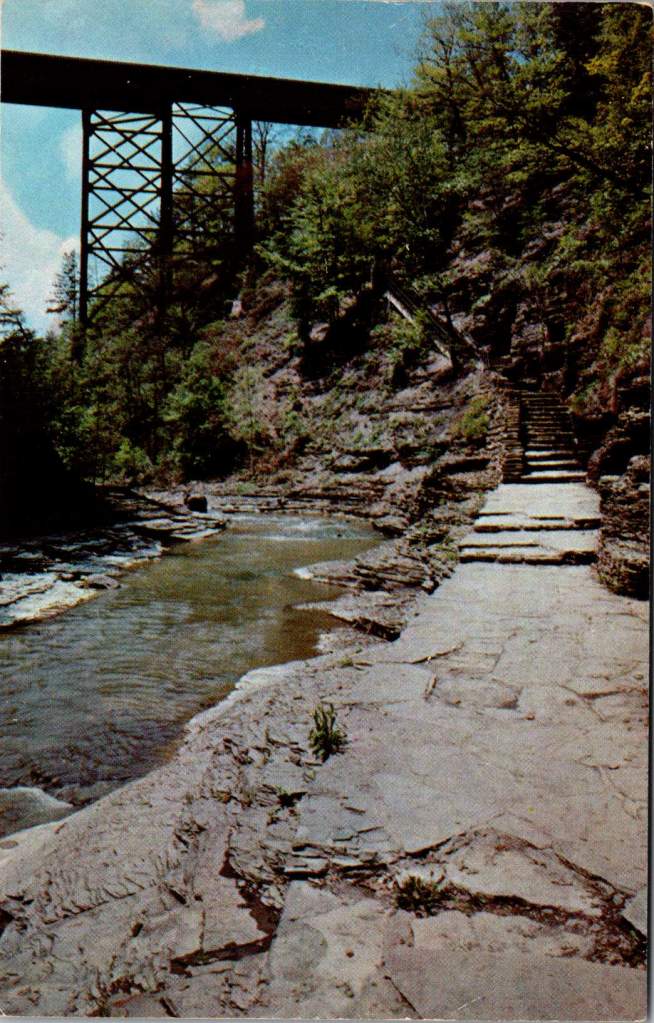
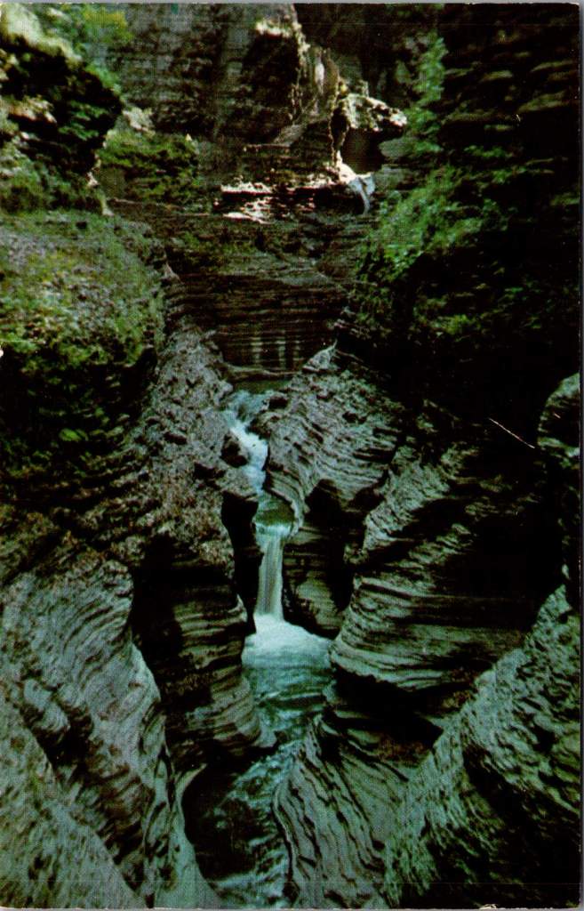
A 1905 hand-colored postcard of Watkins Glen in New York state shows Diamond Falls in the distance, framed by the narrow gorge’s layered rock walls. When the CCC arrived here in the 1930s, they found a park already famous for its natural beauty but in need of significant infrastructure. The Corps constructed the stone walkways that still guide visitors through the glen today, built overlooks at strategic points, and created a trail system that made the park’s dramatic features accessible while preserving their natural character.
The CCC’s work at Watkins Glen was particularly challenging given the varied landscape and unique natural formations. Jacob’s Ladder, a daunting stone staircase ascending the gorge wall, required precise engineering to integrate it naturally into the rock face. The Corps workers quarried stone and shaped the ascent, creating a path that appear to emerge organically from the cliff itself.
At Rainbow Falls, they constructed the “flying stairs” – suspended pathways that seem to float alongside the cascading water. This required not just skilled stonework but innovative engineering to ensure the structures could withstand the gorge’s frequent flooding and harsh winters. The Stairway to Lover’s Lane presented similar challenges, with workers having to carefully cut into the gorge wall while preserving its natural beauty.
The Corps also built the park’s amphitheater, transforming a natural hollow into a gathering space that would host generations of visitors for educational programs. Throughout these projects, workers had to move tons of stone while working in the confined space of the gorge. They developed specialized techniques for working in the narrow spaces, often suspended above the creek as they built pathways that had to withstand both regular flooding and freezing temperatures. The project showcased the Corps’ ability to combine heavy construction with delicate environmental consideration – skills that would prove valuable throughout the park system.
Yet while young men were building parks across America, another story was unfolding at Bear Mountain, New York. A smaller program called the Temporary Emergency Relief Administration (TERA) – nicknamed the She-She-She camps – was offering women their own opportunity for training and education. Eleanor Roosevelt championed this effort, collaborating closely with progressive educator Hilda Worthington Smith to create a program that emphasized both practical skills and broader education.
At Camp TERA, women learned furniture refinishing, bookbinding, typing, and business skills. They studied literature, current events, and public speaking. The curriculum reflected both practical needs and progressive educational ideals, emphasizing peer learning and leadership development. The camps created a college-like atmosphere, quite different from the military structure of CCC camps.
The economics of these programs tell their own story. Spending roughly $1,000 per enrollee annually (about $25,000 in today’s dollars) the CCC cost $3 billion over nine years – equivalent to about $60 billion today. In its time, the program returned an estimated $2.50 in measurable public benefits for every dollar spent. Each CCC enrollee earned $30 monthly, with $25 sent home to their families – enough to keep many families fed during the Depression’s darkest days. The TERA budget was much less and never achieved the scale that made the CCC so cost-effective, yet for some of the women who participated, the return on investment was significant in improving their health, caregiving capacities, and professional skill sets – many went on to careers in business, education, and public service.
The CCC employed three million men over nine years. TERA participants numbered just 8,500 women. Despite Eleanor Roosevelt’s advocacy and Frances Perkins’ support from the Labor Department, the women’s program expanded only briefly and never really got off the ground. The reasons echo familiar themes: limited funding, resistance to women working outside the home, and debates about appropriate roles for women in society.
These limitations weren’t unique to TERA. The CCC itself reflected America’s racial divisions, with segregated camps and discriminatory selection. Some local communities opposed Black CCC camps in their areas. The program’s focus on young, single men also excluded many who needed help.
Yet for all their limitations, the New Deal’s public works programs transformed America’s public spaces. Beyond the CCC and TERA, the Works Progress Administration built parks, schools, and community centers nationwide. WPA artists created murals that still enliven post offices and courthouses today. Collectively, WPA workers built communities, developed national infrastructure, and documented American life through photography and collected folk songs and stories that might otherwise have been lost.
The human legacy of these programs extends far beyond their physical achievements. Chuck Yeager, the pilot who would later break the sound barrier, learned mechanics in the CCC. Stan Musial developed his work ethic in a Pennsylvania CCC camp before becoming a baseball legend. Robert Mitchum and Raymond Burr worked in CCC camps before their Hollywood careers. From the TERA camps emerged teachers, business leaders, and community organizers who shaped their communities for decades to come.
Looking at these vintage postcards today, we can measure the value of these programs not just in the enduring infrastructure they created, but in the generational impact of providing education and opportunity to millions of Americans of modest means. Think of the families fed by CCC wages, the skills learned, the confidence built. Consider the children and grandchildren who grew up hearing stories of carving out Yellowstone’s trails or getting the chance to study at Bear Mountain, who inherited not just the physical legacy of these programs but their spirit of public service and possibility. Think of all of us today, who still climb the steps and set our sights on this same legacy.
The trails around Old Faithful, the stone steps at Watkins Glen, the walkways at Mammoth Hot Springs – all have weathered nearly ninety years now, crossed by millions of visitors. They stand as monuments not just to American craftsmanship, collaboration, and ingenuity but to the transformative power of public investment in both our spaces and our people. They give us examples of leadership and also remind us of the great many unknown men and women who preserved and protected the places we love. Their endurance challenges us to imagine what might be achieved in this generation if we again dared to think so boldly about developing our natural resources and our human potential together.