A Century of Water for the West: Engineering Arizona’s Water Legacy

When photographer Walter J. Lubken documented Roosevelt Dam’s construction in 1906, he captured more than engineering – he preserved the story of how water transformed the American West. See these remarkable images and the ancient and modern legacies they explore.

Deep in the rugged canyons where the Salt River carves through Arizona’s Superstition Mountains, the story of Western water management took shape. This commemorative postcard set, printed in the 2000s, features century-old government documentary photographs that reveal the effort.

The construction of Roosevelt Dam, beginning in 1906, marked not just an engineering milestone but a fundamental shift in how humans would reshape the American West. This massive undertaking would transform both the physical landscape and the social fabric of central Arizona, setting patterns of development that continue to influence the region today.

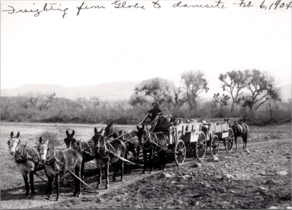
The logistics of construction proved nearly as challenging as the engineering. Materials had to travel either along the Apache Trail, a 60-mile road from Mesa carved from ancient Indian paths, or via a primitive 40-mile trail from Globe. The isolation of the site forced engineers to think creatively about resource management. They solved the critical cement supply problem by establishing an on-site manufacturing facility, a decision that would save over $460,000 (equivalent to more than $13 million today) while ensuring consistent quality control. The photographs show workers carefully weighing and sacking cement in bags marked “U.S.R.S.,” each bag representing both technical progress and economic pragmatism.

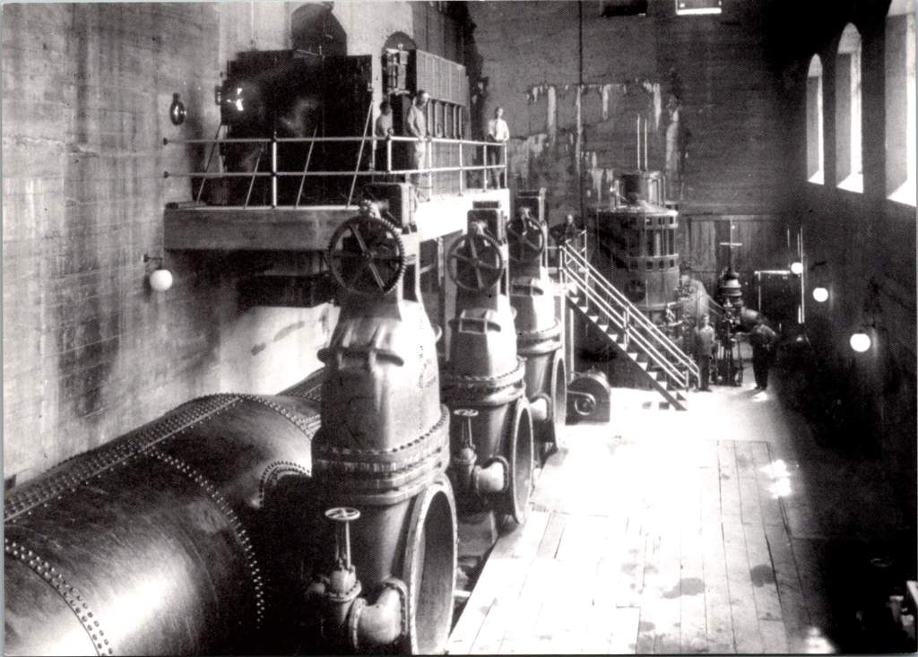
By 1909, the Roosevelt Dam Power House demonstrated another innovative aspect of the project. Housing five 900kW generators and one 5000kW generator, the facility would produce 45,000 kW of electricity by 1912, providing power to Phoenix and surrounding communities. This early integration of water management and power generation established a pattern that would shape the region’s development for decades to come.

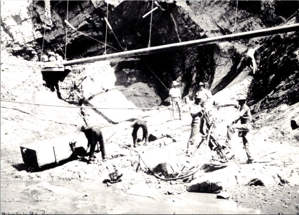
The dam site itself presented formidable challenges that would test the limits of early 20th-century engineering. Rising nearly 280 feet from bedrock, Roosevelt Dam required innovative solutions at every stage of construction. Hydraulic drill operators, their equipment visible in historic photographs from the Walter J. Lubken Collection, faced the initial challenge of preparing foundations in solid rock. These drills, powered by compressed air, bored holes for dynamite charges that would help create the dam’s massive footprint. The rhythmic sound of their work echoed through the canyon, marking the beginning of a new era in desert water management.

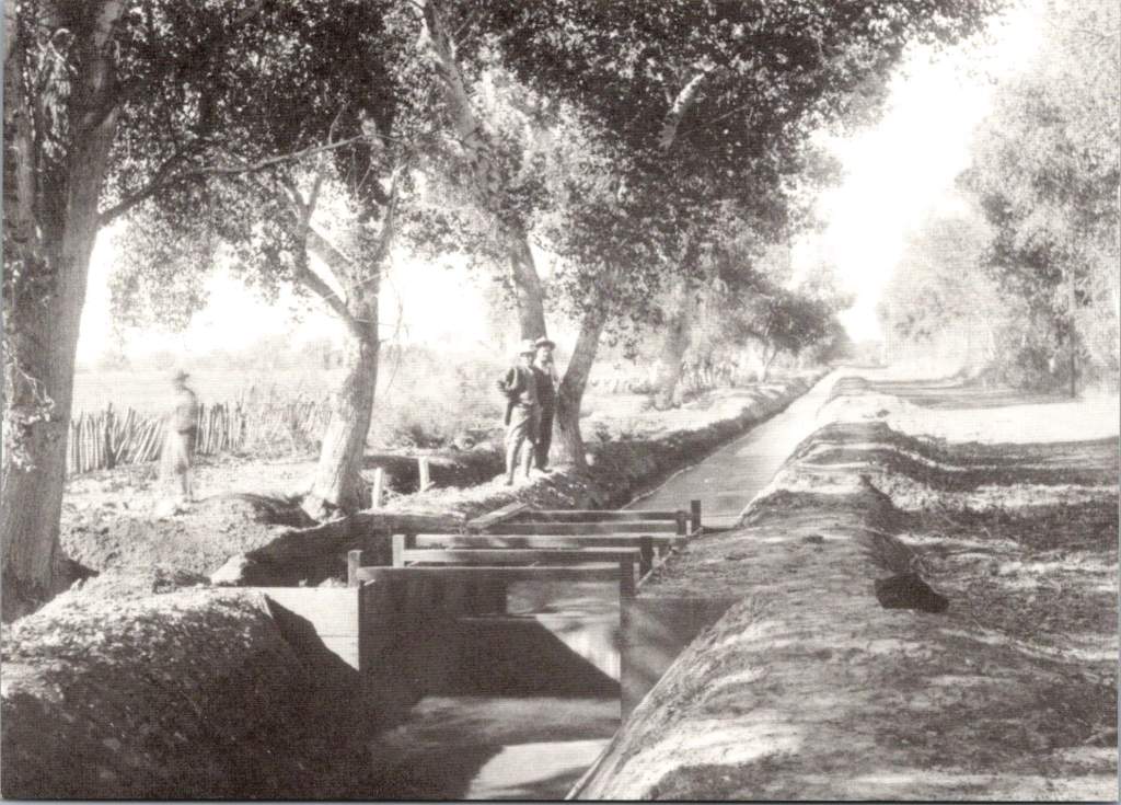
Downstream from Roosevelt, engineers faced a different challenge at Granite Reef Dam. Here, nature provided a crucial advantage in the form of a natural granite reef crossing the river valley. This geological feature offered an ideal foundation for a diversion structure, but working with the hard granite required specialized techniques. Electric U.S. Reclamation Service trains, captured in the historical photographs, transported heavy equipment and materials along the construction site. The completed structure served as the crucial junction point where Roosevelt Dam’s controlled releases would be divided between the Arizona Canal to the north and the South Canal system.

As water flows west from the Superstition Mountains, it enters an increasingly engineered landscape that reveals the ingenuity of early water managers. Near Apache Junction, the canal system had to navigate complex terrain while maintaining the precise gradients necessary for gravity-fed water delivery. Engineers faced a delicate balancing act: the water needed to drop approximately one foot per mile while following natural contours, a requirement that helped determine the location of many early East Valley communities. These seemingly simple measurements would shape development patterns for generations to come.

In Mesa, the system develops additional complexity as it moves through what was once some of Arizona’s most productive agricultural land. The Mesa Canal, dating from territorial days and improved by the Reclamation Service, demonstrates how engineers adapted existing irrigation works into a modern water delivery system.

Near what is now Mesa Community College, the Western Canal branches off, beginning a complex network of distribution that would support the citrus groves and cotton fields that once dominated the landscape. The concrete control gates, many dating from WPA-era improvements in the 1930s, stand as testament to the system’s durability. Each gate represented a critical control point where trusted zanjeros (ditch riders) could manage water delivery with remarkable precision, despite using what we would now consider primitive technology.

As the water system enters Tempe, it reveals layers of engineering history that mirror the city’s transformation from agricultural community to urban center. The Kyrene agricultural district, served by the Western Canal, demonstrates how early engineers maximized gravity-fed irrigation through careful grading and channel placement. The canal’s gradient had to be precisely maintained while following natural contours that would allow for efficient water delivery to agricultural fields. Complex control structures, still visible today near major arterial streets, could be adjusted to deliver specific amounts of water into lateral ditches. These laterals, running north-south at roughly quarter-mile intervals, created the framework that would later influence urban development patterns.

The post-war boom of the 1950s and ’60s presented Tempe’s engineers with a new challenge: how to adapt an agricultural water delivery system for urban use while preserving valuable water rights. Under Arizona water law, rights could be lost if water wasn’t being put to “beneficial use.” This legal framework drove many engineering decisions during the transition period, leading to creative solutions that would shape the modern landscape.

The 1961 development of the Shalimar Golf Course, located between McClintock and Price Roads and between Broadway and Southern, exemplifies the engineering solutions of this era. The course’s design worked within the existing irrigation framework, utilizing lateral ditches that had previously served agricultural fields. The layout preserved the crucial north-south water delivery patterns while adapting them for recreational use.

The late twentieth century brought new approaches to water management that would have amazed the early USRS engineers. At Arizona Falls, located at 56th Street and Indian School Road, modern engineers found a way to honor historical infrastructure while adding contemporary functionality. The site’s 20-foot drop in the Arizona Canal had once powered ice production in the 1890s, helping early Phoenix residents cope with desert summers. Today, this same drop has been transformed into both public art installation and hydroelectric facility, with specially designed turbines that can operate efficiently despite varying water levels. The project demonstrates how historical water infrastructure can be reimagined to serve modern needs while preserving connections to the past.

Perhaps no modern project better exemplifies creative water engineering than Scottsdale’s Indian Bend Wash. This 11-mile greenbelt fundamentally changed how engineers approach flood control in urban areas. Instead of constructing traditional concrete channels that rush water away as quickly as possible, engineers designed a system that mimics natural watershed functions while providing recreational space. The engineering may appear simple to casual observers, but it represents sophisticated water management. Graduated slopes slow flood waters naturally, while carefully calculated retention areas hold excess water until it can safely drain or percolate into the groundwater. At other times, these same spaces serve as golf courses, parks, and bike paths, making the infrastructure an integral part of community life.

The creation of Tempe Town Lake in the 1990s marked perhaps the most ambitious modern reengineering of the Valley’s water infrastructure. Engineers faced multiple complex challenges: maintaining water quality in an artificial lake subject to intense desert sun, managing sediment that once flowed freely down the Salt River, and creating a system that could handle both regular flows and occasional floods. The innovative rubber dam system, recently replaced with hydraulically operated steel gates, had to maintain a consistent lake level while allowing for flood releases during major storm events. What appears on the surface as a simple recreational amenity actually represents one of the most complex water management systems in the Southwest.

The Valley’s own golf courses have evolved from simple users of flood irrigation to pioneers in water conservation technology. Early courses relied on traditional flooding methods inherited from agriculture, and modern facilities employ sophisticated systems that can adjust water delivery down to individual sprinkler heads. Courses along the Western Canal system, such as Dobson Ranch in Mesa, now integrate stormwater capture, irrigation storage, and groundwater recharge into their operations. Their water hazards serve double duty as holding ponds in an intricate water management system that would have seemed like science fiction to the early zanjeros.

Today’s systems employ real-time monitoring technology, allowing operators to adjust water flows remotely in response to changing demands and weather conditions. Computer-controlled irrigation systems at golf courses and parks use weather data, soil moisture sensors, and evapotranspiration calculations to deliver precisely the right amount of water at the right time. These innovations grew from decades of experience managing water in an arid environment, building upon the foundation laid by those early infrastructure projects.

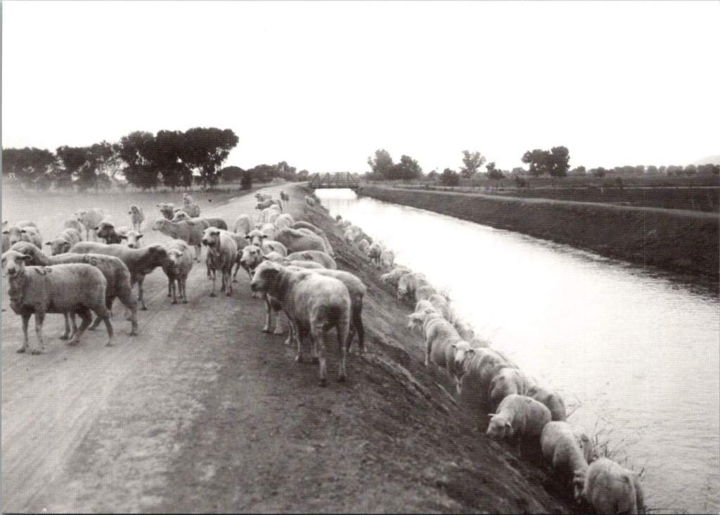
When Walter J. Lubken raised his camera to photograph construction at Roosevelt Dam, he was documenting more than just a construction project. His photographs captured the transformation of the American West from a challenging frontier to a managed landscape. The Bureau of Reclamation’s commitment to thorough photographic documentation served multiple purposes. Engineers could use the images to track construction progress and solve problems. Administrators in Washington could monitor their investment in distant territories. Sheep grazing along canal banks shows how engineers creatively solved maintenance problems while supporting local agriculture. Perhaps most importantly, these photographs reveal important historical details of how federal infrastructure projects were reshaping the American landscape.

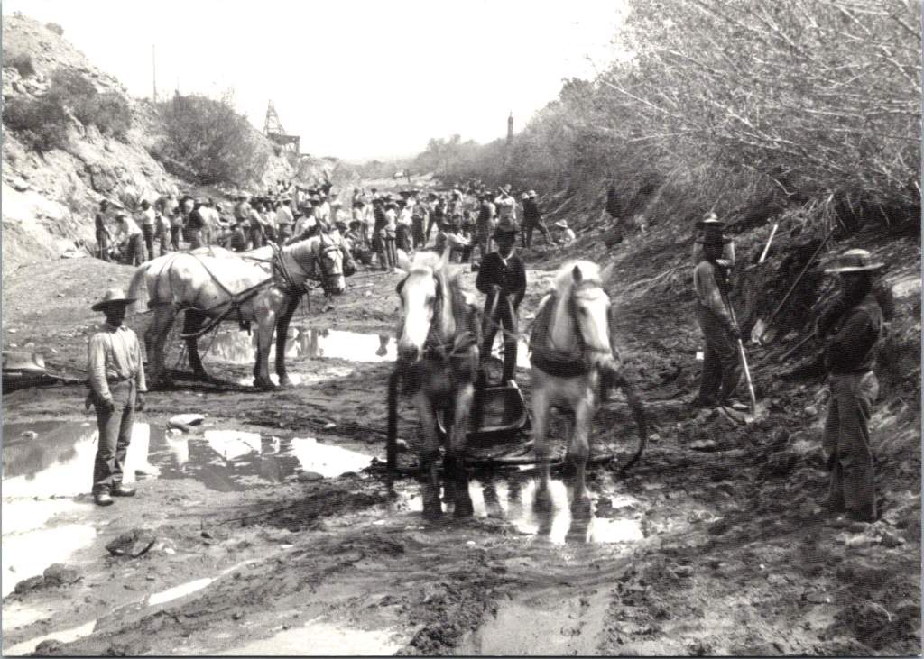
These photographs remind us that water management is ultimately about people: the workers who built the systems, the farmers who used them, and the communities that grew around them. The photo of early canals being excavated by horse and manual labor provides striking contrast with modern construction methods. These historical documents help us understand both how far we’ve come and how much we owe to early innovation.

The Bureau’s decision to commemorate these images in a 2002 postcard set invites us to consider how past engineering decisions continue to shape our present. Every canal, dam, and pipeline represents decisions made by people trying to build better communities. As we face modern challenges like climate change and population growth, these historical images encourage us to think both critically and creatively about water management.

Today’s water managers are creating their own documentation for future generations to study. Digital sensors transmit continuous data about water flow, quality, and usage. Satellite imagery tracks changes in groundwater levels and vegetation patterns. Modern projects like Tempe Town Lake and the Indian Bend Wash are extensively documented not just in photographs but in environmental impact studies, engineering plans, and public meeting records. This documentation will help future generations understand both our achievements and our challenges.

Today’s innovations – whether in golf course irrigation, urban stream restoration, or water recycling – are part of a continuing story of human ingenuity in the face of environmental challenges. Our task is to document our work, both our successes and our mistakes. What will they learn from examining our current water management projects? Perhaps they’ll examine how golf courses became laboratories for water conservation technology.

Like our predecessors, we are trying to balance human needs with environmental stewardship, technological capability with sustainable practice, and individual interests with community benefit. This long view of history reminds us that infrastructure is not just about providing resources today – it’s about designing our desert futures a century from now.

Tempe in Time: A Journey through Places and Postcards

A set of postcards printed in the 1980s reflect Tempe’s history a century before. Now historical artifacts themselves, these images offer a window into the city’s past and future.

As we examine each postcard, we’ll uncover the story of Tempe’s development and explore how each generation has contributed to the city’s evolving landscape.

The Hackett House: Victorian Charm in the Desert

Today’s journey begins with a postcard depicting the Hackett House, a quaint building constructed in 1888. This red brick structure, Tempe’s oldest of its kind, stands as a testament to the city’s early days. With its distinctive turret and elegant design, it exemplifies the rare Arizona Territorial Victorian commercial style.

Originally built by German immigrant William Hilge as Tempe’s first bakery, the Hackett House’s location near the Hayden Flour Mill, the railroad, and the Territorial Normal School (now Arizona State University) nods to the earliest urban planning in Tempe. The postcard captures the building’s 1912 appearance, which was painstakingly restored in the 1970s.

The history of the Hackett House mirrors Tempe’s own evolution. After its days as a bakery, it served as a residence and later a boarding house. It earned its current name when Estelle Craig, Tempe’s first telephone operator, married Roy Hackett in the old bakery house. By the 1980s, when our postcards were likely printed, the Hackett House had already been recognized for its historical significance and placed on the National Register of Historic Places.

Tempe Depot: The Arrival of Progress

Our next stop is the Tempe Depot, captured in a postcard circa 1915. The image shows a steam locomotive at the station, a small group clustered for the photograph. This scene represents a pivotal moment in Tempe’s history, symbolizing the city’s connection to the wider world.

The arrival of the Maricopa and Phoenix Railroad in 1887 transformed Tempe from a small farming community into a thriving center of commerce. The depot, built in 1907, served as a vital link for both passengers and freight, fueling Tempe’s growth and prosperity. Though the original structure was lost to fire in 1923, this postcard preserves its memory and significance.

Arizona Mercantile: Commerce in Early Tempe

The next postcard features the Arizona Mercantile Co., a sturdy brick building constructed in 1898. With its large storefront and a horse-drawn carriage parked outside, this image encapsulates the commercial heart of early Tempe.

The Arizona Mercantile Co. played a crucial role in Tempe’s economy, providing essential goods and services to the growing community. The image itself, its preservation, and later reproduction underscores the importance of local businesses in shaping Tempe’s identity and meeting its residents’ needs.

Laird and Dines Drug Store: A Corner of History

Our final postcard depicts the Laird and Dines Drug Store, circa 1900. This Victorian-style corner building, with its prominent “DRUGS” signage, offers another glimpse into Tempe’s commercial past. The image shows the particulars of storefront business, with its ornate architecture, early signage, and shades to defend against the afternoon sun.

The building went on to serve as campaign HQ for Senator Carl Hayden and Governor Benjamin B. Moeur, as well as the first town hall and post office. Renovations reflected each successive era, including a few that were later reversed. Look closely today, and the old bones still show.

Preservation: Buildings vs. Postcards

As we explore Tempe’s history through these 1980s postcards, we encounter an interesting dichotomy in historical preservation. While some buildings depicted still stand today, others have long since disappeared from Tempe’s landscape.

The preservation of postcards offers a unique window into the past, allowing us to visually experience Tempe as it once was, even when the physical structures no longer exist. The Tempe Depot postcard, for instance, preserves the image and significance of a building lost to fire, serving as a tangible link to the city’s early railroad days.

On the other hand, the preservation of buildings like the Hackett House allows for a more immersive connection with history. Visitors can walk through the same spaces, touch the same walls, and experience the ambiance of a bygone era in a way that a two-dimensional image can’t replicate.

This dual approach to preservation provides a richer, more comprehensive understanding of Tempe’s history. The postcards fill in the gaps where physical preservation was lost, while the preserved buildings offer tactile and fertile connections to the past.

Hayden Flour Mill in operation, click for reference link

Tempe’s Historic Landscape

Tempe’s commitment to preserving its architectural heritage is evident in the numerous historic properties that dot its landscape. The Elias-Rodriguez House, built in 1882 using traditional adobe methods, stands as one of the oldest surviving buildings in Tempe, representing the early Hispanic influence on the city’s development.

The Niels Petersen House Museum, a Queen Anne Victorian style home built in 1892, offers visitors a glimpse into the life of a wealthy rancher in territorial Arizona. The Old Main building on Arizona State University’s campus, completed in 1898, continues to serve the university community while standing as a proud reminder of the institution’s long history.

These pristinely preserved buildings, along with others undergoing substantial redevelopment like the Hayden Flour Mill (1918) form a network of historical touchstones throughout Tempe. They create a physical timeline of the city’s development, allowing residents and visitors alike to trace Tempe’s growth from a small agricultural settlement to a thriving modern city.

Image courtesy of Jack D. Mount, click for reference link

Evolving Landscapes: Tempe Through the Decades

While our postcards capture Tempe’s early history, the city’s development didn’t stop in the early 20th century. Each subsequent generation has left its mark on Tempe’s landscape, contributing important and useful additions that have shaped the city we know today.

The 1960s saw the development of the Mid-Century Modern style that has since become iconic in Tempe. Grady Gammage Memorial Auditorium still defines Tempe’s landscape as a living example of Taliesin West design, inspired by Frank Lloyd Wright’s principles and aesthetic.

Another example, Shalimar Golf Course & Estates, built in 1961 combining a golf course with a mix of single-family and townhomes all featuring the golf lifestyle. This ambitious project represented a new approach to suburban living, offering residents a blend of recreational amenities and comfortable housing. The golf course continues to operate today, though its future faces the threat of redevelopment again in 2025.

As we consider the fate of mid-century developments like Shalimar, we’re confronted with a critical question: will these more recent historical landscapes be preserved in place or will they exist only as postcards, if at all? The answer may depend on how we value and interpret the architectural and cultural legacy of the mid-20th century, and how we balance preservation with the evolving needs of a growing city.

Generational Contributions to Tempe’s Landscape

These projects, spanning a century, demonstrate how each generation in Tempe has contributed something important and useful to the city’s landscape. Each of these developments responded to the needs and aspirations of its time while also shaping the future of Tempe. They’ve created new models for residential communities, transformed the city’s relationship with its natural environment, spurred economic growth, and positioned the city as a cultural hub in the region.

Moreover, these projects have often built upon or complemented earlier developments. For instance, Tempe Town Lake is a modern creation that in some ways echoes the water management innovations seen in earlier projects like the Roosevelt Dam. The Tempe Center for the Arts, with its lakeside location, takes advantage of the views and ambiance and extends the cultural campus of the city.

This layering of infrastructure and development over time creates a rich urban tapestry that tells the story of Tempe’s growth and evolution. From the historic buildings captured in our 1980s postcards to the modern landmarks of today, each generation has added its own chapter to Tempe’s ongoing narrative.

Image from Tempe History Museum collection, click for full citation.

Civic Priorities Across Eras

Examining Tempe’s history reveals how certain civic priorities persist across generations, forming a thread of continuity. The establishment of the Territorial Normal School in 1885 reflects an ongoing commitment to education that continues to shape the city’s identity today. Infrastructure development demonstrates the community’s long-standing recognition of the importance of resource management and large-scale planning.

The presence of telephone services in early Tempe, including Estelle Craig’s role as the city’s first telephone operator, reminds us the community’s need to embrace new technologies. This spirit of innovation has persisted through the decades, manifesting today in Tempe’s adoption of smart city technologies and its support for tech industry growth.

The growth of local businesses and transportation networks demonstrates a consistent focus on economic development that remains a key priority for Tempe. From the early mercantile stores to the bustling mill, and from the first railroad to modern light rail systems, Tempe has always recognized the importance of commerce and connectivity in building a thriving community.

The Past Informing Future Plans

Understanding our history plays a crucial role in shaping the future of our cities, and Tempe is no exception. The walkable, mixed-use nature of early Tempe, where residences, businesses, and civic institutions coexisted in close proximity, still exists as a memory and a footprint within contemporary urban planning that prioritizes regional accessibility and global interaction.

Preserved buildings like the Hackett House do more than just remind us of the past; they actively influence contemporary architectural styles. By maintaining these historical structures, Tempe creates a sense of continuity in its urban landscape. Modern buildings often incorporate elements inspired by these historical designs, creating a blend of old and new that gives the city its unique character over time.

Historic buildings also make spaces for modern vision and mission, as seen with the Hackett House’s current role as headquarters for Tempe Sister Cities. This practice of adaptive reuse not only preserves historical structures but also breathes new life into them, making global connections, welcoming visitors and ensuring Tempe’s relevance for future generations.

The Historic Hackett House today

History Today and Tempe’s Future

As we look at these 1980s postcards of even older Tempe landmarks, we’re reminded that the appreciation of history is itself a constant. Each generation recognizes the value of its heritage and works to preserve it for the future. In doing so, they contribute to the ongoing story of Tempe, creating a richer, more resilient urban fabric that honors the past while embracing the future.

The challenge – and opportunity – for Tempe and cities worldwide lies in maintaining this delicate balance between preservation and progress. By thoughtfully integrating historical elements into modern urban planning, we create spaces that are not only functional and innovative but also deeply rooted in the community’s unique identity and shared history.

Crucially, thinking about the past and future opens a window into creative solutions for present-day challenges. Some old ways of desert living offer valuable clues for sustainable life in modern Tempe. The walkable nature of early Tempe, for instance, provides inspiration for reducing car dependency. The adaptive reuse of buildings like the Hackett House demonstrates how we can minimize waste and preserve cultural heritage simultaneously. The large-scale water management projects of the past have to inform us in dealing with water scarcity in an era of climate change.

As Tempe faces new challenges and opportunities, these historical images and structures serve as both guideposts and inspirations. They remind us that every generation leaves its mark, and that by honoring our past, we can create a more meaningful and sustainable future. The story of Tempe, as told through these postcards and the buildings they depict, is about continuity amidst change and working together. It’s a story that continues to unfold, with each generation adding its own chapter.

In the end, Tempe’s effort to learn from its history while boldly innovating for the future reflects those shared concerns every community faces. It shows that progress and preservation are not mutually exclusive, Rather, they are complementary forces. When balanced thoughtfully, they can create vibrant, resilient, and deeply-rooted urban and suburban communities. As Tempe faces the future, it does so with the wisdom (and the failures!) of its history as a guide, each generation ensuring that the city’s unique character and community spirit will endure for the next.